

Maps & Atlases, Natural History & Color Plate Books
Officers

Caleb Kiffer
Specialist
caleb@swanngalleries.com
(212) 254-4710 ext. 17

David Rivera
Administrator
drivera@swanngalleries.com
(212) 254-4710 ext. 13
George S. Lowry
Chairman
Nicholas D. Lowry
President, Principal Auctioneer
924899
Andrew M. Ansorge
Vice President & Controller
Alexandra Mann-Nelson
Chief Marketing Officer
2030704
Todd Weyman
Vice President & Director, Prints & Drawings
1214107
Nigel Freeman
Vice President & Director, African American Art
Rick Stattler
Vice President & Director, Books & Manuscripts
Administration
Andrew M. Ansorge
Vice President & Controller
aansorge@swanngalleries.com
Ariel Kim
Client Accounting
akim@swanngalleries.com
Diana Gibaldi
Operations Manager
diana@swanngalleries.com
Kelsie Jankowski
Communications Manager
kjankowski@swanngalleries.com
Shannon Licitra
Shipping Manager
slicitra@swanngalleries.com
Maps

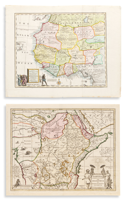

1
(africa.)
Two hand-colored engraved maps.

Vp, vd
Schenk & Valk. Aethiopia Superior vel Interior; vulgo Abissinorum sive Presbiteri Ioannis Imperium. Double-page engraved map of central/eastern Africa, i.e. the mythical kingdom of Prester John. 16½x20¾ inches sheet size, ample margins; original hand-color in outline; very nice. Amsterdam, circa 1700.
Bowen, Emanuel. A New & Accurate Map of Negroland and the Adjacent Countries. Engraved folding map of western Africa. 16½x21 inches sheet size, wide margins; hand-colored; binding edge at left, generally very nice. London, circa 1744.
Estimate
$300 – $400


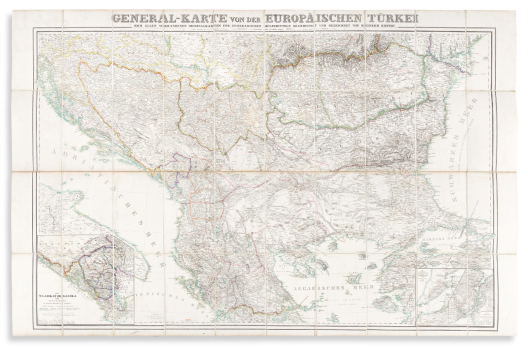
2
(asia minor.)

Np, circa 1900
Large detailed topographic case map of Turkey and part of Syria. 31½x46¼ inches overall, dissected into 40 segments and mounted to original linen with printed advertisement self-wrappers; folding into original cloth slipcase with Edward Stanford label; only minor signs of age.
Seeming to be the western half of a larger German work, here issued by Edward Stanford as a stand-alone map.
Estimate
$250 – $300


3
(balkans / turkey / caucasus.)
Group of 5 uniformly prepared 19th-century regional case maps.

Vp, vd
Folding into original 8vo format green cloth slipcase with John Arrowsmith printed paper label fixed to upper cover; minor signs of age.
Heinrich Kiepert. General-Karte von der Europaischen Turkei. Hand-colored lithograph; 36x55½ inches overall, dissected into 40 segments and mounted to original linen backing with green cloth self-wrappers. Berlin, 1853.
Heinrich Kiepert. Karte von Georgien, Armenien und Kurdistan. Hand-colored lithograph on two sheets joined; 22x30 inches overall, dissected into 16 segments and mounted to original linen backing with green cloth self-wrappers. Berlin, 1854.
John Arrowsmith. Turkey in Europe. Hand-colored engraving; 27x22 inches overall, dissected into 12 segments and mounted to original linen backing with green cloth self-wrappers. London, 1842.
British Hydrographic Office. The Euxine or Black Sea. Engraving; 26¼x39 inches overall, dissected into 21 segments and mounted to original linen backing with green cloth self-wrappers. London, 1853.
Heinrich Kiepert. Constantinopel und der Bosporus. Chromolithograph; 18x11 inches overall, dissected into 4 segments and mounted to original linen backing with green cloth self-wrappers. Berlin, 1853.
Estimate
$500 – $750


4
(baltic states.) ludwig august mellin.
[Atlas von Liefland].

Riga, 1798
General map and 14 detailed district maps in cased format. Engravings with original outline hand-color; each approximately 20x28½ inches, dissected into 8 segments and mounted to contemporary linen backing; No. 5 supplied from another similarly prepared copy; an occasional stain but overall very nice.
Estimate
$1,500 – $2,500


5
(black sea.) c. zirbeck, for the prussian general staff.
Karte der Hauptstrassen von der Niedern Donau bis Contantinopel.

Berlin, 1828
Large lithographed topographical map of coastal Romania, Bulgaria, and the Bosporus. 39x27 inches overall, dissected into 36 segments and mounted to original linen with hanging loops; moderate foxing, small splits along several fold lines.
Estimate
$300 – $400


6
(california.) railroad commission of the state of california.
Official Railroad Map of California.

San Francisco, 1922
Large color-printed case map of the state with an extensive key, town index and inset plans of San Francisco, Los Angeles, Sacramento and San Diego. 52½x41 inches overall, dissected into 64 segments and mounted on original linen; folding into worn original 8vo format gilt-blocked calf case; map generally fine.
Estimate
$300 – $400


7
(california – gold regions.) john t. lawson.
Lawson’s Map from Actual Survey of the Gold, Silver & Quicksilver Regions of Upper California. Exhibiting the Mines, Diggings, Roads, Paths, Houses, Mills, Stores, Missions &c.

New York, 1849
Finely detailed lithographed pocket map. 15¾x21 inches sheet size, folding into publisher's 12mo format gilt-blocked cloth case; archivally lined on verso with thin tissue, light browning along folds; modern quarter-morocco slipcase.
Estimate
$2,500 – $3,500


8
(canada.) george philip & son; after a.& w. mackinlay.
Mackinlay’s Map of the Maritime Provinces of the Dominion of Canada.

London, circa 1900
Enormous color-lithographed case map of New Brunswick, Nova Scotia, and Prince Edward Island. Two panels folding into original gilt-blocked green cloth case; each section 51x33½ inches overall, dissected into 25 segments, and mounted to original linen backing with marbled paper self-wrappers; small area of water damage to rear cover, otherwise excellent with only minor spots of age.
Estimate
$400 – $600


9
(celestial.) cellarius, andreas.
Scenographia Compagis Mundanae Brahea.

Amsterdam, 1661
Hand-colored double-page engraved chart of the Tychonic-model solar system with the large central globe positioned to show Earth’s western hemisphere. 17x20 inches sheet size, margins trimmed; right edge unobtrusively re-attached at the neatline.
Estimate
$400 – $600


10
(charleston.) bradford l. gilbert, architect.
South Carolina Inter-State and West Indian Exposition, Charleston, S.C., Dec. 1, 1901 to June 1, 1902.

New York: Harper & Brothers, 1900
Large format offset color lithographed panorama of the Charleston trade exposition with the racecourse/parade grounds and main auditorium at center. 25x40 inches sheet size, wide margins; backed on modern canvas, minor soft creases and edge repairs.
Fine bird’s-eye view by the Courier Lithographic Company illustrating the early 20th-century trade exposition grounds located on the west-central peninsula of Charleston, modern-day Hampton Park area and campus of The Citadel Military College of South Carolina. OCLC locates one example (Duke University Library), no copies traced at auction.
Estimate
$1,000 – $1,500

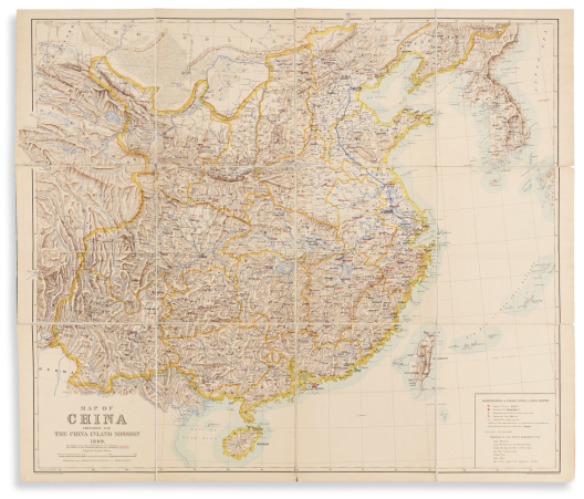

11
(china.) emil bretschneider; and edward stanford.
Map of China Prepared for the China Inland Mission.

London, 1899
Large color-lithographed Christian missionary map of China and Korea. 37x43¼ inches overall, dissected into 12 segments, mounted to original linen backing, and attached to rear cover only of original cloth boards; small fold separations and corner pin-holes, but generally very nice.
Finely detailed map with stations of the China Inland Mission underlined in red and stations of other Protestant Missions underlined in blue. A key at lower right includes a brief glossary of Chinese geographical terms in English.
Estimate
$500 – $750


12
(china.) george philip & son.
Philips’ Commercial Map of China.

London, 1922
Massive color-lithographed map of China indicating shipping routes with a large symbol-keyed table of regional commodities at lower left. 66x45½ inches overall, dissected into 30 segments and mounted to original linen backing with marbled paper self-wrapper; folding into publisher’s lightly worn orange cloth covers including a 24-page handbook to the map by Sir Alexander Hosie; generally very good condition.
Estimate
$300 – $400


13
(civil war.) smith, j. calvin.
The New Naval and Military Map of the United States.

Philadelphia, 1863
Large hand-colored engraved wall map on 4 sheets joined. 67x68 inches overall; black wooden rollers, backed on modern canvas with green silk selvage; various staining, cracks and fissures with small scattered losses.
Large patriotic map of Civil War-era North America within a decorative border of stars, vines, and 30 medallion portraits including Abraham Lincoln, other political leaders, and major Union military figures. The eastern geography of the United States is standard for the period, though further west we find several regions on the cusp of border change at the time of this publication: a wide New Mexico and Arizona Territory (becoming the familiarly-shaped separate territories in 1863); Nevada without its southern tip; one large Dakota Territory; a large cascading Washington Territory, but no Idaho Territory (1863), Montana (1864), or Wyoming (1868).
Insets of nationalistic scenes include flag bearers giving the response of the Army and Navy, an allegorical “Rescue of the Union”, Battle of Bunker Hill, a panoramic view of Washington, DC, the battle of ironclads Monitor and Merrimac; inset statistical maps show annual rainfall and temperature, distribution of plants, trees, and animals, distribution of slave and free colored populations, along with other tables, profiles and charts.
Estimate
$1,000 – $1,500


14
(civil war.) u.s. coast survey; nicholson, walter l. (compiler.)
Map of Eastern Virginia.

Washington, DC, 1862
Chromolithographed map of Virginia from the Chesapeake Bay to Lexington. 26x21 inches sheet size, wide margins; folded into quadrants, light marginal soiling and a few small closed edge tears.
Estimate
$400 – $600


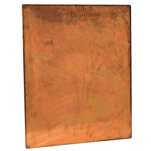


15
(copperplates.) united states geological survey.
Montana - Fort Logan Sheet.

Washington, D.C., 1886 (1914)
Three engraved copperplate printing matrices. 21x17 inches or smaller; approximately 30 pounds together; minor wear, topographic plate with printer’s ink not entirely wiped clean after final pressing (likely removable if desired).
Complete set of USGS printing plates for an approximate 50-mile stretch of the Missouri River in central Montana. Of note for what is not shown on the map, this area is the site of modern-day Canyon Ferry Lake, a dam-created reservoir completed in the 1950s.
Plate 1 - initial layout, toponyms, title and imprint; Plate 2 - rivers and drainage; Plate 3 topographical features.
Estimate
$400 – $600


16
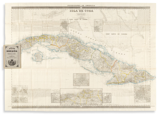
(cuba.) francisco coello.
Isla de Cuba.

Madrid, 1851, 1853
Together two large engraved broadside maps with detailed inset plans, tables, and historical and statistical text panels. 31½x42½ inches each sheet size; hand-color in outline; folding into original 8vo format cloth-backed publisher’s printed boards; overall very fine.
Estimate
$700 – $1,000


17
(cuba.) g.b. haase; and edouard willmann.
Panorama de la Habana, Capital de la Isla de Cuba, la Reina de las Antillas.

Paris, 1855
Large engraved panoramic view of Havana. 20½x44½ inches sheet size, wide margins; scattered stains and repairs.
Estimate
$700 – $1,000


18
(devonshire.) peter schenk; and gerard valk.
Devoniae Descriptio / The Description of Devon-Shire.

Amsterdam, circa 1700
Double-page engraved decorative county map. 20x22¾ inches sheet size, wide margins; outstanding original hand-color; minor age spots but overall excellent.
Estimate
$250 – $300


19
(egypt.) william martin leake, after.
Map of Egypt.

London, circa 1840
Large hand-colored engraved case map of the Nile River described in detail. 51x32 inches overall, dissected into 42 segments and mounted on original linen with blue selvage and marbled paper self-wrappers; folding into original cloth case with James Wyld printed paper label, mild wear; map with light offset but generally fine, Wyld imprint pasted to lower margin.
Estimate
$300 – $400


20
(europe.) r.a. shulz.
Praktische Geschafts und Reisekarte Sammtlicher Staaten von Europa.

Vienna: Artaria & Co., 1860
Large hand-colored engraved traveler’s case map of Europe. 38½x51 inches overall, dissected into 50 segments and mounted to original linen with printed Artaria advertisement self-wrapper card; faint foxing but in general very attractive.
Estimate
$300 – $400


21
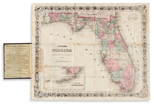
(florida.) g.w. & c.b. colton.
Colton’s Florida.

New York: J.H. Colton, [1855] 1872
Hand-colored lithographed pocket map of Florida with an inset of the Keys. 13½x16½ inches overall, folding into neatly repaired publisher’s 12mo format gilt-and-blind-stamped cloth case; archivally lined on verso with thin tissue stabilizing fold intersections, adhesive stain at mount.
Estimate
$200 – $250


22
(florida.) columbus drew.
Drew’s New Map of the State of Florida.

Jacksonville, 1870
Large lithographed map of Florida with fine original hand-color by county. 26¾x28 inches sheet size, wide margins; light foxing and other small stains, original fold lines slightly darkened and with thoughtful reinforcements to verso, small reinstatement at left margin where removed from original pocket covers.
The first map of Florida printed in Florida.
Estimate
$1,200 – $1,800


A Fine Early Seventeenth-Century Italian Celestial Globe
23
(globes.) giuseppe de rossi; after jodocus hondius.
Globus Coelest, in quo stellae fixæ omnes quæ a N. Viro Tychone Brahe suma cura observatæ sunt, accuratissime dessignantur: quibus adjuncte sunt circa Pol. Aust. stel: quæ a pertiss: nauclero Petro Theodori annotate sunt simul accomodate ad ann. 1614; æditus vero ann. 1615.

[Milan or Rome], 1615
8-inch celestial globe comprised of 12 hand-colored engraved gores, laid horizontally on steel axis pins within a modified turned mahogany stand; globe with only minor unobtrusive wear, green wash applied at original construction aged to an attractive patina, small previous owner's mark to the right of Sagittarius, base with repairs.
The present astral sphere faithfully replicates a slightly earlier globe created by Jodocus Hondius in Amsterdam, 1601; our maker, de Rossi, excludes any acknowledgement to that original source. Whether Rossi used the original Hondius plates versus new gores engraved in Italy, the pert imagery of each emblematic constellation is crisp and dramatic - a delightful way to visualize the celestial skies; the unusual flat format makes for a pleasing overhead tabletop viewing experience.
Edward Luther Stevenson, Terrestrial and Celestial Globes, volume 2, 1921; Peter van der Krogt, Globi Neerlandici.
Estimate
$15,000 – $20,000


24
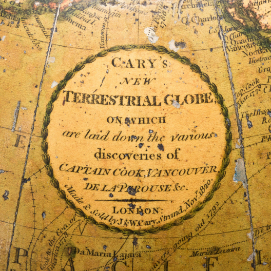
(globes.) j. & w. cary.
Cary’s New Terrestrial Globe.

London, 1820
9-inch table globe comprised of 12 hand-colored engraved gores and a calibrated brass meridian ring on its original four-legged turned maple stand with engraved hand-colored zodiacal horizon band. 14½ inches height overall; scattered nicks and scrapes to outer varnish but no major damages, stand with small spots of wear and repairs.
Estimate
$2,000 – $3,000


25
(instruments – celestial.) leon barritt; and garrett serviss.
The Barritt-Serviss Star and Planet Finder - Northern Hemisphere.

New York, 1906
Moveable circular star chart riveted between a base board and a die-cut top frame. 15x15 inches; some staining and light wear but generally surviving very well.
A handy device to show the visible stars and constellations of the heavens at any given hour of the day, any day of the year. “Revolve the map until the day of the month desired stands opposite the hour of the day you wish, and that portion of the map showing within the opening below, will present the stars and planets in view at that hour. Hold the map over your head - the top north, and you will see the stars just as they appear in the heavens.”
Estimate
$250 – $300


26
(instruments.)
Early pocket compass and sundial diptych.

[Germany?, late 18th to early 19th century]
Magnetic compass pointer with glass face, gnomon string, brass hinges and clasps on hardwood panels mounted with hand-colored engraved paper dials and latitude key. 2¾x1½x½ inches; light wear and soiling but appealing original condition and functional; no maker’s mark.
Estimate
$300 – $500


27
(himalayas.) edward stanford.
A Map of Part of Tibet Including Sikkim, the Chumbi Valley & Bhutan Showing the Routes Between Darjiling and Lhasa.

London, 1904
Large hand-colored lithographed case map of southern Tibet, Sikkim, and Bhutan noting several 20,000-foot peaks. 26½x33¾ inches overall, dissected into 28 segments and mounted to original linen with printed advertisement self-wrapper; folding into publisher's cloth case with printed paper label, some spine wear; map fine; ink stamp of Jackson Memorial High School Library.
Estimate
$300 – $400


28
(iberian peninsula.) direccion general de obras publicas.
Estadistica de Obras Publicas.

Madrid, 1913
Large color-printed lithographed case map of roadways in Spain and Portugal with an inset of the Canary Islands. 39x51½ inches overall, dissected into 50 segments and mounted to original linen with printed advertisement self-wrappers; folding into original cloth slipcase with Edward Stanford printed paper label; Stanford imprint label pasted to lower margin of map; unobtrusive vertical tear throughout, otherwise fine.
Estimate
$250 – $300


29
(indonesia.) dutch east indies topographic department.
Schetskaart van de Residentie Palembang.

Batavia (ie, Jakarta), 1914
Massive color-lithographed topographical case map of southern Sumatra. 4 large panels, each 29x35 inches, dissected into 40 segments and mounted to original linen backing; overall excellent; modern card slipcase.
Estimate
$200 – $250


30
(iowa.) henn, williams & co.; and rufus l. barnes.
A Township Map of the State of Iowa.

Fairfield, IA and Philadelphia, 1855
Large hand-colored lithographed pocket map of Iowa. 21¼x35 inches overall, folding into publisher’s 12mo format gilt-and-blind-stamped cloth case; small repairable fold split at right and minor stains at left but generally quite nice.
Estimate
$300 – $400


31
(iowa.) j.h. millar; and g.h. yewel.
Iowa City and its Environs.

Panora, IA: Bryan & Millar, 1854
Large lithographed plan of Iowa City with decorative side panels. 27½x35 inches sheet size, wide margins; old folds, unobtrusive graphite annotations, but generally speaking quite fine.
Finely detailed map of Iowa City, state capital at the time, skillfully lithographed by William Schuchman of Pittsburgh. The twelve attractive architectural vignettes represent prominent resident’s homes, churches, colleges, and the state capitol building. At left center is the printed trade card of Cook, Sargent & Downey, Bankers & Land Agents; the map was evidently used to endorse their real estate marketing in the expanding town.
Estimate
$800 – $1,200


32
(japan.)
Kokoku Soku Ryo Zenzu.

Japan, Meiji 24 (1891)
Engraved color-printed pocket map of the islands of Japan with statistical panels and over 20 fine scenic vignettes. 20x55 inches overall, folding into orange self-wrappers with printed paper title label; minor rubbing to covers, map fine.
Estimate
$400 – $600


33
(japan.)
Bunka era manuscript scroll with 11 colored differentiations of Japanese feudal Daimyo land holdings.

Japan, Bunka 12 (1815)
Ink and watercolor on thin paper joined with sheets of heavier contemporary stock; 11½x412 inches overall (approximately 34 feet); wear to terminal edges but no major damages.
together with: A similar theme, but here color-printed woodblocks of the 11 maps describing Japanese regions of the Daimyo. Small folio, 12x8½ inches, original blue paper wrappers with printed title label, contents mounted on later card and bound in a leporello format; occasional small worm track stabilized by backing, but still quite nice. Japan, Bunka 12 (1815).
Estimate
$1,200 – $1,800


34
(japan – meiji school geography.)

Japan, 1870’s
Ansha Chizu Higashi Hankyu (Eastern Hemisphere) [and] Ansha Chizu Nishi Hankyu (Western Hemisphere). Together two large color-printed woodblock pocket maps; each two sheets joined and 25¼x19 inches overall, folding into original yellow self-wrappers with printed paper title labels; excellent condition. Meiji 8 (1875).
and:
Chigaku Kotohajime. 7 color-printed woodblock folding maps (World, Asia, Europe, Africa, South America, North America, and Oceania). 3 volumes. 8vo format, 7x5 inches, original stitched yellow wrappers with printed paper labels; light wear and soiling. Meiji 3 (1870).
Estimate
$600 – $900


35
(japan – nikko.)
Group of 3 nineteenth-century tourist guides to the mountain resort town north of Tokyo.

Japan, vd
Guide Map of Nikkosan, Japan. Beautifully engraved perspective map with pictorial vignettes and insets of carriage roads and steamship lines. 2 sheets joined, 20x29 inches overall; very fine, folding into original printed paper outer envelope. Meiji 17 (1884).
Color-printed woodblock plan of Nikko. 12¾x17¼ inches; very fine, folding into original printed paper outer envelope. Circa 1870. <
Nikko Meisai Ki. Guidebook with 4 attractive double-page color-printed woodblock illustrations. 8vo format, 6¼x4½ inches, tan paper wrappers with printed paper title label; overall very nice with only minor wear. Meiji 14 (1881).
Estimate
$600 – $900


36
(japan – perry.)
Shokei Kingoku Okatame Ezu Men. [U.S. Commodore Matthew Perry’s arrival in Japan, July 8th, 1853].

Japan, Kaei 6 (1853)
Large woodblock kawaraban broadside on four sheets joined; 23x22¼ inches overall; original folds, a few small early repairs but no major damages.
Unusually designed large format kawaraban depicting Perry’s Black Ship squadron arriving at Edo Bay.
Estimate
$1,200 – $1,800


37
(japan – perry.)
[U.S. Commodore Matthew Perry’s arrival in Japan, July 8th, 1853].

Japan, circa 1853
Manuscript scroll of ink lettering on 5 sheets of thin paper joined, woodblock kawaraban broadside tipped to right edge. 11x71 inches overall (printed illustration sheet 9¼x11 inches); some staining but no tears or other major damage.
Official manuscript report announcing the arrival of Perry’s fleet into Edo, mentioning the 4 Black Ships and their outfitted armaments (106 guns), officers, crew, etc. The attached contemporary woodblock kawaraban titled “Amerika Sen” is a fine detailed portrait of one of these ships.
Estimate
$1,000 – $1,500


38
(japan – perry.)
[U.S. Commodore Matthew Perry’s arrival in Japan, July 8th, 1853].

Japan, circa 1853
Fine woodblock kawaraban broadside on thin paper featuring a stylized portrait of Perry and a large depiction of one of his Black Ships at Edo Bay. 10¾x14 inches sheet size, wide margins; two repairs at right but still a rather nice example of an uncommon variant.
Estimate
$1,000 – $1,500


39
(japanese / russian trade relations.)
Imperial Russian Navy Admiral Yevfimiy Putyatin’s diplomatic fleet at Osaka Bay.

Japan, Kaei 7 (1854)
Color-woodblock kawaraban broadside. 13½x18½ inches, wide margins; folds, mild soiling, skillful old repairs.
Rare color-printed kawaraban depicting Russian Admiral Yevfimiy Vasilyevich Putyatin’s squadron entering Osaka Bay in late 1854.
In the wake of American Commodore Matthew Perry’s successful opening of Japan in 1853, Putyatin sailed into Osaka attempting to gain an audience with Shogunate officials. After a brief stay, Putyatin found himself ushered from Osaka and was requested to continue to Shimoda where a meeting of diplomatic negotiations would be arranged. As the fleet sat anchored at Shimoda on December 23, 1854, a tremendous earthquake struck the area causing a tsunami which destroyed the fleet and damaged the flagship Diana’s hull beyond repair. With a collaborative effort between the Russians and local Japanese carpenters a schooner was built in a matter of months that was large enough to carry Putyatin and his crew back to their homeland. This was the first western-style ship built in Japan and an early instance of Japanese learning western technology, models of which were quickly incorporated into their own naval fleets.
Before departing, Putyatin and Japanese officials negotiated the Treaty of Shimoda, ending Japan’s centuries-long policy of international isolationism. The treaty opened Japan’s ports to Russian commerce and defined the northern territorial borders between the two Empires.
Estimate
$1,800 – $2,200


40
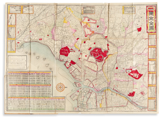
(japan – tokyo.)
Group of 3 Meiji-period color-printed engraved pocket maps of Tokyo illustrated with pictorial vignettes.

Japan, vd
Kaisei Tokyo Zen Zu. 2 sheets joined, with additional descriptive panel pasted to lower margin; 20½x29½ inches, folding into publisher's cloth-backed paper-covered wooden case with printed paper title label; quite fine overall with bold colors on high-quality paper shimmering with mica. Meiji 21 (1888).
Tokyo Zen Zu. 2 sheets joined; 20¾x29 inches, folding into publisher's cloth-backed printed paper-covered card case; fine condition. Meiji 26 (1893).
Tokyo Jisoku Zen Zu. 4 sheets joined; 24¼x28½ inches, folding into publisher's cloth-backed printed paper-covered card case; fine condition. Meiji 28 (1895).
Estimate
$1,200 – $1,800


41
(japan – world war i.)
Offset color-lithographed Japanese pictorial map of Europe at the outset of World War I.

Tokyo, Taisho 3 (1914)
21½x31 inches; old folds, two small stains and minor edge wear.
Manga-style map depicting naval positioning and troop movements with large caricatures of British, Russian, French, German, Austrian, and Serbian soldiers.
together with: Ashura Cho. Volume of 100 color woodblock cartoons with printed captions. 8vo format, 10x8½ inches, original woodblock-printed paper boards stitched with heavy cord, minor rubbing. Japan, Taisho 10 (1921).
Among other general topics, some themes involve World War I and the wake of the war, the Siberian Intervention (or Siberian Expedition), and international politics - including a cartoon depicting Woodrow Wilson's defeat of Charles Evans Hughes in the 1916 American presidential election.
Estimate
$700 – $1,000


42
(japan – world war ii.) japanese ministry of the navy.
Two monumental Japanese naval maps: [World] and [Europe].

Japan, Showa 14 (1939)
Sekai Taisei Yozu. Large offset color-printed naval intelligence map of the world on 4 sheets joined. 57x77 inches overall; folded, scattered staining and wear from use, but generally nice. --Impressive world map describing the naval strengths of Japan, United States, Great Britain, Nazi Germany, France, Italy and the Soviet Union at the outset of World War II.
Oshu Yozu. Large offset color-printed naval map of Europe on 4 sheets joined. 76x59 inches overall; folded, scattered stains.
Estimate
$1,800 – $2,200


43
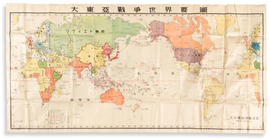
(japan – world war ii.) japanese imperial naval office.
Dai Toa Senso Sekai Yozu.

Japan, Showa 17 (1942)
Large offset color-printed Japanese naval intelligence map of the world on 4 sheets joined. 42x84 inches overall; folded, generally fine with minor spots of foxing and occasional irregular folds.
Published by the Japanese Naval Office one year into World War II, this monumentally-sized chart shows the world at war and records all the major Japanese naval conflicts from December 8, 1941 to November 1942. Focusing on the Pacific theater, some noted battles and events include Pearl Harbor, Battle of Midway, Battle of the Coral Sea, the sinking of the U.S.S. Lexington, the invasion of the Aleutians and Japanese submarines off the California coast for the bombardment of Ellwood.
Estimate
$1,500 – $2,500


44
(japan – world war ii.) japanese ministry of the navy.
Wagakuni Yushu Tsunyu Jokyo.

Japan, Showa 3 (1928)
Enormous offset color-printed data visualization map of the world on 4 sheets joined. 58½x81 inches overall; folded, generally excellent with only minor scattered foxing.
Oversized chart referencing trade goods, raw materials, and other economic resources around the world, but with particular concentration on the naval strengths of Great Britain (vertical bar graph at left), Japan (center), and the United States (right); a focused intelligence chart by the Japanese Naval Department demonstrating the Empire’s vulnerability as compared to other world powers. The Washington Naval Treaty of 1922 limited the Allied nations of World War I from naval construction in the hopes of avoiding an international arms race; The London Naval Treaty of 1930 (two years after this map was published) sought to further increase regulations. Within several years Japan had officially renounced these sanctions with an eye towards major naval expansion, a clear concern and goal illustrated by this map, and an obvious indication that conflict was brewing.
Estimate
$1,200 – $1,800


45
(kansas.) g.w & c.b. colton.
Colton’s New Sectional Map of the State of Kansas Compiled from the United States Surveys & Other Authentic Sources.

New York, 1867 (1870)
Large hand-colored lithographed pocket map of Kansas on two unjoined sheets. Approximately 27¼x24½ inches each sheet size; minor staining and wear to lower right margin, gentle verso reinforcements to several fold areas; loosely inserted into original 12mo format gilt-and-blind stamped cloth case, neatly rebacked. Heaston, Kansas Pocket Maps 16.
Estimate
$500 – $750


46
(korea.) hayashi shihei; after.
Chosen Koku Zenzu.

Japan, Tenmei 5 (1785)
Large manuscript map of the Kingdom of Korea. Ink and watercolor on 4 sheets of thin paper joined, 30x22 inches overall; old folds, minor early repairs.
Hayashi Shihei, a Japanese scholar with military interests, put forth one of the earliest attempts to define the boundaries of Japan with a concern for security and national defense in his work Sangoku Tsuran Zusetsu (Illustrated General Survey of the Three Countries). Shihei’s book was banned by the government in 1792 and practically all copies were destroyed. The maps within the book were preserved and perpetuated in manuscript copies, such as the present. The map delineates the peninsula of Korea and surrounding islands, notably showing Takeshima/Dokdo, whose claim has long been disputed with Japan.
Estimate
$1,200 – $1,800


47
(london.) pierre aveline; after.
Londres Ville Capitale du Royaume d’Angleterre.

Paris: Jean Francois Daumont, circa 1760’s
18th-century engraved view of London. 14¼x21½ inches sheet size, ample margins; original hand-color in full; two short repairs.
Estimate
$400 – $600


48
(london.) cary (family); sold by g.f. cruchley.
Cary’s Map of the Country 12 Miles Round London.

London, circa 1840
Hand-colored engraved map of London and vicinity. 23½x29½ inches overall, dissected into 18 segments and mounted to original linen with green selvage and cloth self-wrappers; folding into original green cloth slipcase with printed paper label; Cruchley imprint pasted to lower margin; all around quite fine with exceptional original colors.
Estimate
$400 – $600


49
(london.) g.f. cruchley.
From the Ordnance Survey of the Country Thirty Miles Round London.

London, 1860
Large hand-colored engraved case map of London and vicinity. 43¾x54¼ inches overall, dissected into 50 segments and mounted to original linen with marbled paper self-wrappers; strong original hand-color; splits and reinforcements to several fold lines.
Estimate
$350 – $400


50
(maine.) j. chase, jr.
Map of York County Maine.

Philadelphia and Boston: J.L. Smith, 1856
Hand-colored engraved wall map detailing towns along the southern coast of Maine. 4 sheets joined, 57x55 inches overall; mounted on original linen backing and ebonized wooden roller rods; moderate cracks, chips and stains.
Estimate
$600 – $800


51
(massachusetts.) george colton.
Plan of Springfield.

[Springfield, MA], 1835
Large hand-colored engraved plan of the Springfield and Chicopee vicinity identifying local property ownership in excellent detail. 33½x28 inches sheet size; professionally restored with small losses filled, backed on modern canvas.
Scarce map of Springfield, Mass done by contemporary resident George Colton; a famous name in map-publishing, though our man is more obscure and not to be confused with the dominant 19th-century New York City publisher owning the same handle. OCLC locates less than five examples.
Estimate
$800 – $1,200


52
(mexico.) girolamo tasso.
Confederazione Messicana.

Venice, 1835
Double-page engraved map of Mexico, Texas, the American southwest and Gulf Coast with letterpress text panels in Italian. 15x20½ inches sheet size, wide margins; original hand-color in full; small eighth-inch loss at upper center.
Estimate
$250 – $300


53
(mexico city.) edward mogg; after diego garcía conde.
Plan General de la Ciudad de México, Levantado por el Teniente Coronel Don Diego Garcia Conde, en el Año de 1793, y Gravado en Miniatura en Londres por Edouard Mogg, el Año 1811.

London, 1811
Engraved folding plan of Mexico City with extensive reference key. Dissected into 15 segments, 21x23½ inches overall; original wash color; modern archival lining on verso, minor toning and offsetting; modern morocco-backed clamshell box.
Smaller-format second edition of Conde’s influential 1807 plan of Mexico City; though here engraved on a reduced scale, Mogg succeeded at faithfully reproducing every bit of the thorough detail seen on the grand-scale original map.
Estimate
$1,500 – $2,500


54
(michigan – copper mining.) luther g. emerson.
Topographical Map of the Portage Lake Mining District.

Handcock, MI: 1888
Large hand-colored lithographed pocket map denoting land-ownership within the copper mining district on Michigan’s Upper Peninsula. 39½x31 inches overall, dissected into 48 segments, mounted to original linen, and folding into publisher’s 8vo format gilt-blocked cloth case; front cover detached but present, small fold split at upper right, else very nice. OCLC locates just 4 copies.
Estimate
$400 – $600


55
(micronesia.) francisco coello.
Islas Marianas, Palaos y Carolinas.

Madrid, 1852
Large engraved broadside map with detailed inset plans, tables, historical and statistical text panels. 31x42 inches sheet size; touches of hand-color; folding into original 8vo format cloth-backed publisher’s printed boards; minor abrasion along one fold line, else fine.
Estimate
$150 – $200


56
(minnesota.) lieutenant james allen.
Map of the Route Passed Over by an Expedition Into the Indian Country in 1832 to the Source of the Mississippi.

Washington, D.C., 1834
Engraved map of central Minnesota locating the source of the Mississippi River, from Henry Schoolcraft and James Allen's Expedition to Northwest Indians in 1832; 23rd Congress, House Doc. No. 323. 17x20 inches sheet size, wide margins; original folds, small repair at lower left, foxing.
Estimate
$100 – $150


57
(minnesota.) simeon p. folsom, surveyor.
Mankato.

New York: George Hayward lith., circa 1852
Large lithographed plat of the town extending from the crook of the Minnesota River at Front and Main Streets. 24x38 inches sheet size, wide margins; old folds, a few annotations in ink and graphite.
Scarce early cadastral map of Mankato; OCLC locates two examples.
Estimate
$300 – $400


58
(montana territory.)
Rand, McNally & Co.’s Indexed County and Township Map of Montana With a New and Original Compilation and Index Designating All Post Office Towns and Railroad Stations, and Giving Full Postal Directions for Sending Mail Matter to Every Place Not a Post Office, in the Territory, Known in the Post Office Department as “Locals”.

Chicago, 1883
Color-printed lithographed pocket map. 13¾x20¾ inches sheet size, folding into publisher's 8vo format gilt-blocked green cloth case containing a 12-page reference booklet; map detached from single adhesion point at rear of pamphlet and overall fine; small contemporary ink stamp to title-page: "Robert Grix, Bookseller and Stationer, Butte City, Montana Ter."
Finely detailed separately published map of Montana Territory six years before statehood. OCLC locates no copies.
Estimate
$500 – $750


59
(montana.)
Perspective Map of the City of Helena, Mont… Compliments of Kessler’s Brewery.

Milwaukee: American Publishing Co., 1890
Large tinted lithographed birds-eye view of Helena with inset architectural vignettes and numbered reference key. 28x42 inches sheet size, wide margins; minor edge tears. Reps 2090.
Estimate
$500 – $750


60
(new jersey.) william kitchell.
Topographical Map of the State of New Jersey Together with the Vicinities of New York and Philadelphia and with Most of the State of Delaware.

Philadelphia, 1860
Hand-colored engraved wall map of New Jersey on 4 sheets joined. 67½x58 inches overall; competently restored with no major losses, backed on modern canvas.
A major draft of the Garden State - compiled by state geologist William Kitchell as an update to Thomas Gordon’s first official map of New Jersey (1828). The map’s considerable size and accuracy are balanced quite well on the aesthetic end, including two dozen inset maps and vignette views of local towns in the surrounding areas and the whole enclosed by a robust foliate border design.
Estimate
$1,500 – $2,500


61
(new mexico.) atchison, topeka and santa fe railway.
Map of New Mexico, 1887, Issued by the Santa Fe Route.

Chicago: Rand, McNally & Co., 1887
Large color-printed lithographed map of New Mexico. 23x21½ inches overall, folding into verso-printed promotional self-wrappers; fold separations closed with tape, a few small losses.
Printed in various shades of green indicating the limits of the Atlantic & Pacific R.R. land grant, public lands open for settlement, government lands, military forts, Indian reservations, and Spanish grants. Verso comprises 18 promotional panels outlining regional advantages to potential late-19th-century settlers in New Mexico including particulars of land-acquiring opportunities and costs, climate, agriculture, horticulture, mineral resources, and public schools.
Estimate
$500 – $750


62
(new orleans.) benjamin moore norman.
Norman’s Plan of New Orleans & Environs.

New Orleans: B.M. Norman, 1845
Hand-colored engraved pocket map of New Orleans with concentric distance circles at ¼-mile intervals and a 71-point keyed reference legend below. 18x24½ inches overall, folding into publisher’s 12mo format gilt-and-blind-stamped red roan case; modest strengthening to a few fold versos but on the whole exceptionally well preserved; publisher’s printed shop ticket pasted to inside cover.
A beautiful copy of an apparently unrecorded pocket map.
In 1845 Benjamin Norman published his guidebook to New Orleans which included a very similar engraved plan of the city with credit given to Henry Mollhausen for the survey. That “first” edition is itself quite scarce however, no standard references we’ve consulted cite the variant pocket version seen here.
In the present plate quite a few engraved differences can be found when compared to the 1845 guide version: a different script is used at the title; Mollhausen’s name does not appear; our reference key notes 71 locations versus 80; a larger explanation and scale table is here; riverfront treatment differs; and frankly on closer inspection one realizes this is an altogether different plan covering less area and with less toponym detail, features which lead us to surmise it was separately published and pre-dates the “first” guidebook edition.
Jumonville, Bibliography of New Orleans Imprints 1412; Charting Louisiana 180 - (both citing the 1845 guidebook edition).
Estimate
$3,000 – $5,000


63
(new york.) john homer french.
The State of New York from New and Original Surveys.

Syracuse, NY: Robert Pearsall Smith, 1860
Large hand-colored engraved wall map of New York with many inset views and detail maps. 68x73 inches overall, dissected into 16 segments and backed on original linen with marbled paper self-wrappers; well-preserved with only faint staining and minor wear at fold intersections.
Estimate
$700 – $1,000


64
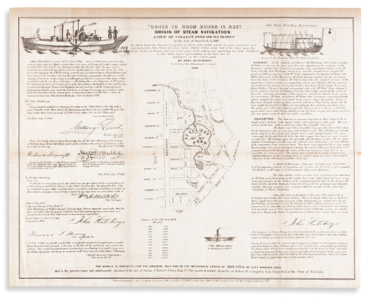
(new york city.) john hutchings.
“Honor to Whom Honor is Due.” Origin of Steam Navigation. A View of Collect Pond and its Vicinity, in the City of New York in 1793.

Williamsburgh, L. Island, 1846
Lithographed broadside of testimonial remarks commemorating John Fitch, Robert Fulton, and Robert Livingston's contributions to the invention of a successfully operating steam-powered boat, illustrated with vignettes and a map of the original Collect Pond with a contemporary street grid overlaid. 15¼x19 inches sheet size, ample margins; original folds, minor discolorations or offset.
Estimate
$200 – $250


65
(new york city.) george schlegel.
New York, Taken from Central Park.

New York: George Degen, 1874
Hand-finished color-tinted lithographed view of Manhattan looking south from Central Park. 19x25 inches sheet size, ample margins; registration pinholes; skillful old repair into image at right.
Uncommon vista of Manhattan - the bird’s-eye perspective is set from Belvedere Castle and many recognizable features of Central Park are plainly seen: The Ramble, The Lake, Bethesda Terrace and Fountain, Bow Bridge, and Sheep Meadow; several other buildings, pavilions, and architectural elements appear which no longer stand. The city, bounded by the Hudson and East Rivers, recedes from Central Park South down to the Brooklyn Bridge and the Bay beyond.
Rare, with but three institutional copies located and no market records. Reps 2716.
Estimate
$4,000 – $6,000


66
(new york city – brooklyn.) hyde & company.
Map of the Borough of Brooklyn, City of New York.

Brooklyn, 1899
Large hand-colored lithographed map of Brooklyn. 32x29½ inches sheet size, wide margins; issued folding, here flat and backed on period linen, a few repairs and early annotations in ink and colored pencil.
Estimate
$350 – $450


67
(new york city – brooklyn.) e. belcher hyde.
Map of the Borough of Brooklyn. City of New York.

Brooklyn, 1906
Chromolithographed wall map of Brooklyn with touches of hand-color. Two sheets joined, 69x59 inches overall; original linen backing and pink selvage, original wooden rollers with brass end caps and hanging loops; minor toning at upper and lower edges but essentially astonishing condition for an item of this nature.
Estimate
$800 – $1,200


68
(north america.)
Two hand-colored engraved maps.

Vp, vd
Bowen, Emanuel. A New and Accurate Map of New Jersey, Pensilvania, New York, and New England. 14½x18 inches sheet size, ample margins; scattered repairs throughout image and margins. London, circa 1744.
Kitchin, Thomas. North America Drawn from the Latest and Best Authorities. 14x16¼ inches sheet size, ample margins; original folds, minor edge wear. London: For John Harrison, 1787.
Estimate
$300 – $400


69
(ohio – cleveland.) ahaz merchant, surveyor.
Two early hand-colored lithographed plats of lot divisions within the vicinity of downtown Cleveland.

Vp, vd
[S.]S. Stone's Subdivision of Part of Original Lot No. 50, in the Township of Brooklyn, and Within the Corporate Limits of the City of Ohio. 25½x19½ inches sheet size; folds, edge wear, graphite annotations. Buffalo: Hall & Mooney lith., June, 1848.
S.S. Stone's Allotment of Part of 10 Acre Lots, Nos. 1 & 2. Part of 100 Acre Lot No. 487 & Part of Original 2 Acre Lots, Nos. 125 & 126 in the City of Cleveland. 18x23½ inches sheet size, folds, edge wear, graphite and ink annotations. Cleveland: J. Beattie lith., June, 1853.
Estimate
$300 – $400


70
(paris.) jacques de la tynna.
Environs de Paris.

Paris, circa 1817
Circular engraved case map of Departements surrounding Paris. 31½x31 inches, dissected into 24 segments and laid on original linen backing; original hand-color in outline; “De la Tynna” signature in ink at lower left corner beneath his printed name; light age toning, “Map Department April 1968” ink stamp at upper left corner; Goujon advertisement ticket and bookplate of John William Simpson pasted to verso; original green paste-paper case.
Estimate
$200 – $300


71
(paris and environs.) andriveau-goujon.
Cased set of 9 color-lithographed detailed topographic maps.

Paris, 1895
Each sheet 17x20 inches, dissected into 8 segments and mounted on original linen backing with printed Andriveau-Goujon labels pasted to verso; folding into 8vo format book-form case with gilt morocco spine label; box with moderate wear, maps fine.
[Pontoise / Les Mureaux].
[St. Denis / Montmorency Forest].
[Dammartin-en-Goële / Mitry-Mory].
Versailles.
Paris.
Lagny-sur-Marne.
Chevreuse.
Sceaux.
Brie-Comte-Robert.
Estimate
$300 – $400


72
(philadelphia.) nicholas scull; and george heap.
A Map of Philadelphia and Parts Adjacent.

London: Gentleman’s Magazine, 1777
Engraved folding map of the city and surrounding areas along the Delaware and Schuylkill Rivers. 15x12¼ inches sheet size; unobtrusive crease at lower left, right margin partially trimmed for binding.
Estimate
$300 – $400


73
(philadelphia.) john hills.
A Plan of the City of Philadelphia and Environs.

Philadelphia, 1808 [1809]
Large hand-colored engraved circular wall map of greater Philadelphia with two allegorical vignettes at lower corner spandrels. 9 sheets joined, 41x41 inches overall; significant restorations, mounted to modern canvas with old ebonized wooden roller rods; manuscript annotations in an early hand.
Estimate
$4,000 – $6,000


74
(philadelphia.) john bachmann, after.
Bird’s Eye View of Philadelphia.

New York: J.H. Locher; and Switzerland: J.U. Locher, circa 1850
Large color-tinted lithographed panorama of the city. 24½x33 inches sheet size, wide margins; archivally lined on verso, small marginal restorations not affecting image.
Fine perspective of a thriving mid-19th-century Philadelphia. Drawn on stone by Gustav Matter after Bachmann’s original view, the panorama looks west from the Delaware River waterfront. Names can be seen on a few of the paddle-wheel steamships, two of them discreetly giving a nod to the artist and publisher with a small portrait of each. Reps 1584.
Estimate
$1,500 – $2,500


75
(philippines.) francisco coello.
Islas Filipinas.

Madrid, 1852
Large engraved broadside with several detail maps, tables, and extensive historical and statistical text. 32¾x43¼ inches overall, dissected into 32 segments and mounted to original linen; partial hand-color; no major flaws and generally very nice. Part of a larger work, but stands well on its own.
Estimate
$400 – $600


76
(pictorial maps.) richard edes harrison.
An Aerial View of New York City.

New York: Herald Square Hotel, circa 1931
Lithographed bird’s eye view of New York City looking north from Washington Square; verso with printed pamphlet advertisements. 8¾x16 inches overall; original folds, light dampstain at lower edge. First state without the Lincoln Tunnel or World’s Fair site.
Estimate
$150 – $200


77
(pictorial maps.) tony sarg.
The New York [1940] World’s Fair Map.

Boston, 1939
Offset color lithograph map of the Flushing Meadows fairground and exhibit areas printed on treated linen. 13½x21½ inches overall; “1940” stencil-painted over original printed 1939 date, metal pull-out clasp at right edge with minor wear at handle point, stapled to wooden roller dowel at left; overall a fine, bright example without the souvenir cane case.
Estimate
$300 – $400


78
(pictorial maps.) miguel covarrubias.
Pageant of the Pacific.

San Francisco: Pacific House, 1940
Set of 6 large offset color lithographed maps. 25x38 and 19x25 inches each sheet size; without portfolio or descriptive pamphlet; soft vertical creases at center from original wooden dowel binder, a few points of minor margin wear but otherwise bright examples.
After the stylish, vibrant murals painted by Covarrubias for the Pacific House on Treasure Island which served as the premier exhibit of the 1939 San Francisco Golden Gate International Exposition. Each map title implies a relation of cultural resonance particular to the Pacific islands, but the maps provide a much broader pictorial representation of the socio-demographic distribution for most other parts of the world.
I. Peoples of the Pacific.
II. The Fauna and Flora of the Pacific.
III. Art Forms of the Pacific Area.
IV. Economy of the Pacific.
V. Native Dwellings of the Pacific Area.
VI. Native Means of Transportation in the Pacific Area.
Estimate
$300 – $400


79
(pictorial maps.) the crawfords.
Group of 21 hand-printed textile maps.

Jamestown, RI, late 1940’s/early 1950’s
Variously colored screen-prints on cotton fabric. Approximately 12x18 inches each; occasional light foxing.
A marvelous suite of mid-20th-century pictorial placemat maps hand-fashioned by a little-known husband and wife duo, George and Margaret Crawford, at their home in Jamestown, Rhode Island.
Each map offers appropriately simplified geographic detail with pleasant, familiar, illustrated emblems - they are very distinctive with a certain retro kitsch appeal. Titles include:
* Northern California and Nevada.
* Southern California/Arizona.
* Oregon/Idaho.
* The Great Lakes.
* Door County/Green Bay, Wisconsin.
* [Northern] Michigan.
* Detroit and Vicinity.
* North Carolina.
* South Carolina/Georgia.
* State of Florida and Gulf of Mexico.
* Suburban Philadelphia.
* Washington D.C./Del-Mar-Va.
* New York City/Manhattan I.
* Long Island.
* Adirondacks/Thousand Islands, New York.
* Vermont.
* Cape Cod.
* Nantucket.
* Watch Hill, Rhode Island.
* Block Island, R.I.
* Chart from Newport to Bermuda.
Estimate
$500 – $750


80
(pictorial maps – china.)
Group of 3 large offset color-printed posters of Chinese natural and cultural heritage sites.

China, mid-twentieth century
Taishan Mingsheng Tu. Scenic trail map of Mount Tai. 30½x42½ inches, wide margins; original folds, minor wear; retaining its slightly damaged original printed paper outer envelope. 1958.
Hang Zhou Xi Hu Quan Jing Tu. Perspective panorama of West Lake, Hangzhou. 19¾x30 inches, wide margins; original folds, short tape repairs to verso. 1964.
Yihe Yuan Niaokan Tu. Bird's eye view of the Summer Palace, Beijing with descriptive text on verso. 21x30¼ inches, wide margins; original folds, fine condition. 1963.
Estimate
$400 – $600


81
(pictorial maps – data viz.) roy wenzlick & co.
A Century of Real Estate Trends. [and] Basic Barometers of Real Estate Trends.

St. Louis, 1951; 1952
Together two large-scale offset color printed broadside charts presenting data-driven maps and diagrams relating to mid-20th century United States real estate and housing statistics. 24x39¼ inches each sheet size; occasional soft creasing though no major flaws; original shipping tube with Wenzlick & Co. label addressed to a San Francisco capital investor.
Two outstanding visual charts compiled by Roy Wenzlick, a prominent 20th-century real estate economist group.
“A Century of Real Estate Trends” - the central map illustrates Percentage Change in the Number of Dwelling Units by Counties: 1940 to 1950; the panels at top and bottom chart Real Estate Activity and Business Activity from 1850 to 1950; a series of graphs at left center shows the Construction Cost of Six Standard Buildings (California bungalow, five-room brick house, six-room frame house, six-room brick house, 18-family brick apartment building, and a 30-unit concrete apartment building); at right center are shown Factors Affecting Real Estate Sales and Values from 1900 to 1950 (such as building material costs, mortgage activity, residential interest rates, etc.); Corporate Earnings, Dividends and Taxes from 1940 to 1950; Trend in Farm Values from 1910 to 1950; and Shrinkage in the Purchasing Power of the Dollar from 1939 to 1950 (represented by stacks of pennies and value decreased by almost half in the short timeframe).
“Basic Barometers of Real Estate Trends” - main map presents Percentage of Change in Total Population by Counties: 1940 to 1950; the upper panel delineates Real Estate and Business Activity from 1850 to 1950; below that is Shrinkage in the Purchasing Power of the Dollar from 1900 to 1950 (with an even more depressing decrease than the earlier pattern); at left are seen Construction Costs Continue to Climb; Factors Affecting New Building; Taxes, Savings and Expenditures; Farm Value, Taxes and Income; at lower right are six graphs showing Regional Patterns of Real Estate Activity from 1890 to 1950 (New England, East Central, West Central, South, South, Southwest and West Coast) with notations pointing out the model of an 18-year cycle of booms and depressions to the market.
OCLC locates no more than three examples of each sheet, with the Milwaukee County Public Library listed as the only institution owning both.
Estimate
$400 – $600


82
(pictorial maps – ireland.) d. edward heffernan.
Dublin in 1861.

Dublin, 1861
Large steel engraved plan of central Dublin peppered throughout with elevations of important architecture in a believable 3-D style, surrounded by 36 oval vignettes. Printed on India paper, 25x36½ inches sheet size, mounted to a larger plate-marked sheet; a few creases and marginal tears, lined on verso with thin conservation stock. OCLC locates a single example, British Library.
Estimate
$1,500 – $2,000


83
(railroads.) rand, mcnally & co.
A Correct Map of the United States of America, Showing the Atchison, Topeka and Santa Fe R.R. and Connections.

Chicago, circa 1882
Color-printed lithographed railroad map. 15½x27½ inches overall, folding, promotional pamphlet on verso; minor wear at fold intersections.
Showing rail connections from Kansas City to Denver and mining towns in Colorado, on through New Mexico and Arizona to California and northern Mexico. Pamphlet verso contains agent information, schedules, connections and regulations, a large pictorial advertisement for Las Vegas Hot Springs, New Mexico, and another pictorial promoting the “Event of the Year… the National Mining and Industrial Exposition at Denver, August 1st to September 30th, 1882”. Modelski 63 (citing a slightly different 1888 edition).
Estimate
$300 – $400


84
(railroads.) g.w. & c.b. colton.
Map Showing the Union Pacific Railway and Connecting Railroads.

New York: Rufus Adams & Co. 1883.
Large lithographed railroad map of the United States west of the Mississippi River. 24x34 inches sheet size; state borders and railway lines hand-colored in outline; minor separations at a few fold intersections otherwise crisp and fine; bound in: Report to the Stockholders of the Union Pacific Railway, for the Year 1882. 8vo, 9x6 inches, original plain wrappers, ex-library stamps.
Estimate
$250 – $350


85
(railroads – illinois.) w.g. wheaton.
Map of the Rock Island and Peoria Railroad Showing Its Connections with Other Railroads.

Peoria and Chicago, circa 1855
Railroad map of Illinois north of St. Louis lithographed by Henry Acheson. 28x21¾ inches sheet size, wide margins; old folds, no real flaws.
Uncomplicated railroad map identifying well over a dozen contemporary lines and connections within the state of Illinois. No copies located, however a similar map with updates by Wheaton can be found at the Beinecke Library, Yale University.
Estimate
$400 – $600


86
(roman empire.) jean baptiste bourguignon d’anville.
Orbis Romani pars Occidentalis * Orbis Romani pars Orientalis.

London: Laurie & Whittle, 1794
Together two double-page engraved sheets forming a map of the Mediterranean region as far north as Great Britain and the Black Sea. Approximately 28½x21¼ inches each sheet size, margins shaved at left and right; original hand-color in outline; split center folds and other small tears reinforced on verso.
Estimate
$80 – $120


87
(rome.) giovanni giacomo de rossi; and jacob de rubeis (eng).
Urbis Romae Novissima Deleineatio MDCL.

Rome, 1650
Engraved plan of ancient Rome with a keyed legend locating nearly 130 sites. 16x21¼ inches sheet size, margins trimmed to platemark; light edge soiling, small tears.
Estimate
$200 – $250


88
(russia – railroads.) edward stanford.
Stanford’s Railway Map of European Russia.

London, 1915
Large hand-colored lithographed map of European Russia with railway lines overprinted in red. 49¼x39¼ inches overall, dissected into 42 segments and mounted to original linen with printed advertisement self-wrappers; folding into lightly worn original cloth slipcase with printed paper labels; minimal wear and a few pencil annotations to the map, ownership markings to verso.
Estimate
$250 – $300


89
(scandinavia.) august hahr.
General Karta Ofver Sverige, Norge och Danmark Samt Angransande Delar af Ostersjo Lander Jemte Jernvags Kommunikationer.

Stockholm: F.& G. Beijer, 1887
Enormous chromolithographed railway map of Sweden, Norway and Denmark with adjoining parts of the Baltics and Finland in two sections, each segmented and mounted to original linen with marbled self-wrappers bearing "North" and "South" printed paper labels. 34x53 inches each section size, folding into original 8vo format cloth-covered card slipcase with Edward Stanford paper label; case with light wear, map fine; Stanford label pasted to lower right margin of bottom map panel.
Estimate
$300 – $400


90
(swabia.) jacques michal; and matthaus seutter.
Suevia Universa.

Augsburg, circa 1725
Hand-colored engraved wall map of modern-day Baden-Württemberg state in southwest Germany hemmed in by the Rhine and Lech Rivers. 56x61½ inches overall, dissected into 60 segments and mounted on period linen backing; original hand-color in full; moderate wear and signs of age, small manuscript annotation at title.
Including major cities of Heidelberg, Stuttgart, Strasburg, Basel, Zurich, Ulm, Augsburg, etc. Decorative title-cartouche and symbol-keyed legend at upper corners; allegory of regional river gods at lower right.
Estimate
$500 – $750


91
(texas.) william brady.
Glimpses of Texas: Its Divisions, Resources, Development and Prospects.

Houston, 1871
Hand-colored lithographed folding map of Texas with insets of the United States and Houston by E.H. Cushing, 104 pages, printed errata slip pasted to inside cover. 8vo, 7x4¼ inches (map 13x15 inches), original printed wrappers, front cover split and reattached; map with several splits at folds.
Scarce pamphlet by Houston real estate broker Brady, inviting immigration to Texas with general descriptions of resources and opportunities. Howes B714; Graff 387.
Estimate
$1,200 – $1,800


92
(texas.) james hamilton young.
Map of the State of Texas.

Philadelphia: Thomas, Cowperthwait & Co., 1853
Hand-colored lithographed pocket map of Texas with insets of the northern portion and Galveston Bay. 13x15¾ inches overall, folding into publisher’s 12mo format black roan case gilt-stamped “Mitchell’s Map of Texas”; closed tear at mount, folds reinforced on verso with minor flaked losses.
Estimate
$500 – $750


93
(thousand islands.) george rockwell.
Map of Part of the Thousand Islands of the St. Lawrence River Near Alexandria Bay, N.Y.

New York, 1875
Lithographed pocket map centered on Wellesley Island with the Canadian side of the boundary hand-colored in red and the American (New York) side in green. 19x23½ inches overall, folding into publisher’s gilt-blocked cloth case, front cover detached but present; small fold separations, else fine.
Estimate
$200 – $250


94
(united states.) tranquillo mollo.
Vereinigte Staaten in Nord America.

Vienna, circa 1818
Double-page engraved map of eastern North America. 15x20 inches sheet size, wide margins; some outline hand-color; minor soiling and edge wear.
Estimate
$150 – $200


95
(wisconsin.) [charles lapham].
Map of the Lakes & Drives, Around Oconomowoc, Wisconsin: A Favorite Summer Resort.

Milwaukee, last quarter 19th century
Lithographed map of the Oconomowoc lake district west of Milwaukee. 14¾x19½ inches sheet size; old folds with small separations, moderate edge wear.
Scarce map of the lake region of Waukesha County engineered into an advertisement broadside for George P. Gifford’s hotel in the heart of the nineteenth-century resort community. A printed red star locates Gifford’s house on the northern bank of Lake Oconomowoc and is keyed to a promotional description below the map.
Estimate
$150 – $200


96
(wisconsin – real estate promotion.) horace greeley.
Map of Madison and the Four Lake Country, Dane Co. Wis.

Np, circa 1855
Large cerograph map of the initial town layout, lakes, and connecting railroads of the Madison vicinity with a panel of descriptive text at right. 19½x29½ inches sheet size; scattered stains and repairs.
Estimate
$250 – $300


97
Andriveau-goujon, eugene; and alexandre vuillemin.
Carte Generale des Etats-Unis et du Mexique Comprenant L’Amerique Centrale et Les Antilles.

Paris, 1862
Large hand-colored engraved case map of North America with several insets. 26½x38 inches overall, dissected into 21 segments and mounted to original linen backing, folding into publisher's 8vo format gilt-blocked brown cloth case; overall excellent.
Finely detailed French case map focused on Civil War-era United States; an early edition naming several early or proposed western Territories including Nevada, Arizona, Minnesota, Nebraska, Utah, Colona (ie Colorado), Shoshone (ie Idaho), and Dagotah [sic].
Estimate
$500 – $750


98
Arrowsmith, aaron.
Chart of Rio de la Plata: The Coast Line from the Spanish Survey; The Banks and Soundings Principally from a Manuscript Chart Communicated by Capt. Donnelly, R.N.

London, October 1st, 1807
Large engraved chart of the Rio de la Plata with insets of the Port of Maldonado and Port of Monte-Video. 22¼x31¼ inches overall, dissected into 9 segments and mounted on original linen with silk selvage and vellum case-tab; light staining.
Arrowsmith’s characteristic exacting detail of the estuary’s coasts of Uruguay and Argentina. OCLC locates three examples of an 1809 edition and two from 1820; one example of the present 1807 traced at auction, 1990.
Estimate
$800 – $1,000


99
Blaeu, willem.
Hollandia Comitatus.

Amsterdam, circa 1640
Double-page engraved map of Holland with fine decorative elements. 16½x21½ inches sheet size, ample margins, Dutch text on verso; original hand-color in outline; moderate aging, but a nice example.
Estimate
$300 – $400


100
Braun, georg; and hogenberg, franz.
Two hand-colored double-page engraved town views from Civitates Orbis Terrarum.

Cologne, [1572]
Approximately 16x20 inches each sheet size, ample margins, Latin text on verso; minor edge wear, two panels of the Italian plate separated and rejoined unobtrusively.
(‘s-Hertgoenbosch, Leuven, Mechelen.) Buscumducis Oppidum Ludo Literario, & Puonaci Populo Nobile… / Lovanium Perantiqua Brabantiae Urbs… / Nitidissimae Civitatis Mechlin…
(Acquapendente, Treviso.) Aquapendente / Tarvisi.
Estimate
$250 – $300


101
Braun, georg; and hogenberg, franz.
Group of 5 double-page engraved French and Belgian town plans from Civitates Orbis Terrarum.

Cologne, [1572]
16½x21 inches each sheet size, wide margins, Latin text on verso; minor flaws but generally a very nice uncolored group.
(Chartres, Chateaudun.) Autricum, Ptolemeo in Gallia Lugdunensi Urbs; Vulgo Cum Villa Nouano Chartes. / Chasteaudunum, Comitatus Vulgo Dunoys in Gallia Oppidum Primarium.
(Cambrai.) La Ville de Cambray.
(Dunkerque, Gravelines and Bourbourg.) Duynkercke / Grevelinge / Borborch.
(Mons, Arras.) Montes, Hannoniae Metropolis / Atrebatum, Episcopalis et Metropolitica Artesiae Civitas.
(Lille.) Lille Insula Ryssele.
Estimate
$500 – $750


102
Braun, georg; and hogenberg, franz.
(Cambridge.) Cantebrigia, Opulentissimi Anglie Regni, Urbs Celeberrimi Nominis, ab Academie Conditore Cantabro, Cognominata.

Cologne, [1575]
Double-page engraved city plan from Civitates Orbis Terrarum. 16¼x21½ inches sheet size, wide margins, Latin text on verso; minor marginal spotting and edge wear.
Estimate
$400 – $600


103
Braun, georg; and hogenberg, franz.
(Kozhikode or Calicut, Ormuz, Kannur.) Calechut Celeberrimum Indiae Emporium. / Ormus. / Canonor.

Cologne, [1572]
Several engraved views of towns along the west coast of India on a double-page sheet. 15¾x20¾ inches sheet size, wide margins, Latin text on verso; small spots of marginal loss simply reinstated, horizontal crease.
Estimate
$150 – $200


104
Braun, georg; and hogenberg, franz.
(Paris.) Lutetia Vulgari Nomine Paris, Urbs Galliae Maxima.

Cologne, [1572]
Double-page engraved city plan from Civitates Orbis Terrarum. 16¼x21½ inches sheet size, wide margins, Latin text on verso; light age toning, minor marginal wear.
Estimate
$800 – $1,200


105
Brue, adrien.
Group of 7 double-page engraved maps with original outline hand-color.

Paris, 1822 or after
21x26¾ inches each sheet size, wide margins; minimal edge tears; author’s small circular blindstamps.
Carte Generale des Etats-Unis, du Haut et Bas Canada.
Carte des Iles Antilles, des Etats-Unis de l’Amerique-Centrale, et de la Mer du Mexique.
Carte Generale des Etats-Unis Mexicains et des Provinces-Unis de l’Amerique Centrale (shorter margins, but still wide).
<br.Carte Generale de Colombie, de la Guyane Francaise, Hollandaise et Anglaise.
Carte du Bresil et d’Une Partie des Pays Adjacents (folding flap, more margin damage than the others).
Carte de l’Empire d’Alexandre.
Carte Generale du Monde Connu des Anciens.
Estimate
$600 – $900


106
Burleigh, l.[ucien] r.[inaldo].
Great Barrington, Mass.

Troy, NY, 1884
Large hand-colored multi-stone lithographed bird’s-eye view of the town of Great Barrington and the Berkshires of western Massachusetts keyed with a numbered legend identifying 23 locations. 21½x36 inches sheet size, wide margins; registration pinholes; soft creases and several short edge tears; “Library of Congress Surplus Duplicate” ink stamp to verso. Reps 1459.
Estimate
$800 – $1,200


107
Carey, mathew.
A New and Accurate Map of North America.

Philadelphia, 1814
Double-page engraved map of North America. 16¾x20½ inches sheet size, wide margins; original hand-color in outline; scattered stains, repair at lower center fold.
Estimate
$200 – $250


108
Hondius, jodocus.
America.

Amsterdam, 1606 or after
Double-page engraved map of North and South America with appealing decorative elements and an inset scene of native peoples preparing and drinking a fermented beverage. 15½x20½ inches sheet size, blank verso; a crisp dark impression; small edge losses, center fold reinforced on verso. Burden 150.
Estimate
$1,800 – $2,200


109
Janssonius, joannes.
Nova Anglia Novum Belgium et Virginia.

Amsterdam, 1636 or after
Double-page engraved map of the northeast American coast. 19¾x23¼ inches sheet size, wide margins; original hand-color in outline; glued to board, toned and foxed; ie needs restoration. Burden 247.
Estimate
$150 – $200


110
Jefferys, thomas; after james rennell.
A New General Map of the East Indies… and the Dominions of the English East India Company.

London: Laurie & Whittle, 1794
Large engraved folding map of India, Southeast Asia, and parts of China. 25x28¾ inches sheet size, ample margins; fine original hand-color in full; fold reinforced at lower center.
Estimate
$500 – $750


111
Melish, john; and henry schenck tanner, engraver.
Map of the Seat of War in North America.

Philadelphia, [circa 1812]
Hand-colored engraved map of northeastern North America printed on “T.Gilpin & Co./1810” watermarked laid paper. 14¾x22¼ inches sheet size, margins shaved close; staining at right, repaired horizontal tear throughout.
Separately published first issue of a map which was subsequently re-engraved to be included in Melish’s 1813 “Military and Topographical Atlas of the United States”.
As Melish writes on page 3 of that work: “The first map in the list is The Seat of War in North America. Previous to the declaration of war, the author had travelled extensively in the north and west parts of the United States, collecting authentic information regarding the present state of the country, and had moved to Philadelphia to put his travels to press. Knowing how unsatisfactory topographical and statistical information is without good maps, particular attention was paid to select the best and most authentic maps in the country, from which to construct those for the travels. While engaged in drawing them, a much valued friend [Henry Schenck Tanner] suggested the propriety of drawing a general map of the seat of war, and proffered the use of a very ample set of excellent maps in his possession. Of these, the author gladly availed himself; the map was produced, and immediately received the stamp of public approbation. It sold so rapidly, that the first plate was soon worn out, and a new one has since been brought forward, enlarged and much improved.”
The present map is slightly smaller and significant differences of engraving can be seen when compared to that of the version found in the “Atlas”. This edition not in Phillips.
Estimate
$700 – $1,000


112
Melish, john; and henry schenck tanner.
Seat of War in Europe.

Philadelphia, circa 1813
Engraved map of the European region involved in the Napoleonic Wars with a statistical table noting population of the allied powers and French coalition. 16½x22½ inches sheet size, ample margins; original wash and outline hand-color; pigments oxidized and offset, original folds split and repaired with film-tape to verso.
Interesting map of northern Europe during the final years of the Napoleonic Wars.
Surprisingly rare: The map is mentioned on advertisement lists found in a few contemporary Melish publications however we are unable to trace any copies in OCLC, dealer, or auction records.
Estimate
$500 – $750


113
Mercator [family.]
[World and Continents].

Amsterdam: Jodocus Hondius, circa 1633
Together 5 double-page engraved maps: Orbis Terrae Compendiosa Descriptio; Europa; Africa; America Sive India Nova; Asia. Approximately 17¾x22 inches each sheet size, wide margins, French text on verso; original hand-color in full; general age toning, scattered foxing and centerfold repairs, Africa with a small hole at center.
Estimate
$7,000 – $10,000


114
Miscellaneous maps.
Group of 13 double-page engraved maps.

Vp, vd
European makers, 16th-18th centuries.
John Speed. The Countie of Radnor. Trimmed to neatline, small edge tears (Sudbury & Humble).
Vaugondy. Partie de l’Amerique Septentrionale (mid-Atlantic coast). Trimmed within neatline, horizontal fold, small edge damages.
John Ogilby. The Road from London to the City of Bristol. Hand-colored, minor edge wear.
John Ogilby. The Roads from London to Bath & Wells. Hand-colored, small loss at upper left margin, several filled worm holes.
Braun & Hogenberg. Marchena/Orchuna. Short margins, damaged edges.
Daniel Stoopendahl. Het Beloofde Landt Canaan. Hand-colored, scattered stains.
Giovanni Albrizzi. Carta Geografica della Provincia del Friuli. Hand-colored, clean.
Covens & Mortier. l’Ancienne Thebaide ou les Desarts d’Egypte. Original hand-color, close margins, scattered stains.
Willem Blaeu. Mechlinia Dominium et Aerschot Ducatus. Original outline hand-color, age toned, small edge wear.
Willem Blaeu. Pictaviae Ducatus Descriptio. Original outline hand-color, age toned, edge stains and repairs.
Johannes Janssonius. Guiana sive Amazonum Regio. Hand-colored, repairs and discoloration at center fold and lower margin.
J.B. Homann. Tabula Generalis Iutiae. Original hand-color, narrow margins, edge repairs.
Vaugondy. Carte de la Barbarie. Outline hand-color, horizontal fold, scattered spots.
Estimate
$500 – $750


115
Mitchell, samuel augustus; and james hamilton young.
Mitchell’s Travellers Guide Through the United States.

Philadelphia: S. Augustus Mitchell, 1842
Hand-colored engraved pocket map of the eastern United States with inset vicinity plans of 8 cities. 18x22 inches overall, folding into publisher’s 12mo format gilt-and-blind-stamped red roan case with 78-page booklet of text; covers moderately worn, map with only minor wear at fold intersections and generally a very crisp example.
Estimate
$300 – $400


116
Münster, sebastian.
Tabula Graeciae [Ancient Greece].

Basel, circa 1550
Double-page woodcut map of Ptolemaic Greece. 11¾x15¼ inches sheet size, wide margins, Latin text on verso; minute filled wormholes at lower center, else fine.
Estimate
$200 – $250


117
Ortelius, abraham.
Americae Sive Novi Orbis, Nova Descriptio.

Antwerp, 1598
Double-page engraved map of the Western Hemisphere. 18x21½ inches sheet size, wide margins, French text on verso; attractive in an uncolored state; minor edge soiling and light spots of foxing. Burden 39; Van den Broecke 11 1598F5.
Estimate
$3,000 – $5,000


118
Ortelius, abraham.
Turcici Imperii Descriptio.

Antwerp, 1592
Double-page engraved map of the Middle East. 16x20½ inches sheet size, ample margins, Latin text on verso; fine original hand-color in full; a few minor edge tears but overall very nice. Van den Broecke 169 1592L 104.
Estimate
$600 – $900


119
Phelps, humphrey.
Phelps’ Map of the United States, from the Best Authorities.

New York, 1834
Engraved wall map printed on 3 sheets joined, with three large engraved vignettes added below. 46x57 inches overall; original hand-color in full; backed on original linen with ebonized wooden rollers; ably restored with scattered areas of small loss sympathetically filled (mostly at blank areas, minimally affecting printing).
A custom prepared wall composition - unrecorded variant of Phelps’s 1833 map of the United States, but here including a rare third sheet illustrating the sprawling territories west of the Rocky Mountains; made altogether more unique with the joining of two scarce Revolutionary War engravings by John Baker and a portrait of George Washington engraved by Illman & Pilbrow below the map.
Estimate
$3,500 – $5,500


120
Price, charles; and john senex.
Africa Corrected from Observations of Mess. of ye Royal Societies at London and Paris.

London, 1711
Large engraved map of Africa with a fine provincial title cartouche on two sheets of laid paper joined. 27½x38¾ inches overall, ample margins; original hand-color in outline; a handful of short edge tears closed and strengthened on verso but still presenting quite nicely.
Estimate
$800 – $1,200


121
Ranney, adolphus; and rufus blanchard.
Map of the United States.

New York, 1854
Large hand-colored electrotype cerograph pocket map of the United States and patriotic title-vignette within a decorative pictorial border. 22¼x30¼ inches overall; neatly repaired publisher’s 12mo format gilt-and-blind-stamped roan case detached but present; folds as issued, occasional strengthening to verso, minor offsetting, adhesive stain at left edge.
Attractive representation of the United States showing most of the expanse west of the Missouri River as pre-statehood territorial regions, each delineated in fine original hand-color.
Estimate
$700 – $1,000


122
Ruggles, edward.
A Map of Massachusetts Connecticut and Rhodeisland [sic].

Walpole, N.H., Feb 1819
Large hand-colored engraved case map southern New England. 4 sheets joined, 30¼x37¾ inches overall, dissected into 20 segments and laid on original linen with marbled paper self-wrappers; light wear but generally quite nice.
An excellent example of this scarce map of New England, stylishly engraved by little-known Vermont tradesman Moody Morse Peabody in January 1819.
Estimate
$1,200 – $1,800


123
Sanson, guillaume.
Atlantis Insula.

Paris, 1699
Double-page engraved map of the “Ancient” American continents. 21x30 inches sheet size, extra wide margins; original wash color; scattered foxing and stains, would conserve nicely. Burden 405, 4th state.
Estimate
$400 – $600


124
Speed, john.
A Map of New England and New York.

London: Basset and Chiswell, 1676
Double-page engraved map New England scattered with illustrations of regional fauna. 16¼x21¼ inches sheet size, ample margins, English text on verso; nicely hand-colored in outline; moderate foxing, very small closure at upper margin.
Estimate
$1,800 – $2,200

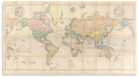

125
Stanford, edward.
Stanford’s Library Map of the World on Mercator’s Projection.

London, circa 1895
Large color-lithographed case map of the world. 38x68¾ inches overall, dissected into 40 segments and mounted to original linen backing with marbled paper self-wrappers; original hand-color in full; without case; small fold splits, otherwise nice.
Estimate
$300 – $400


126
Taintor bros. & merrill.
Map of the North Western States and Territories. Including Kansas, Nebraska, Dakota, and Region West to the Pacific Ocean.

New York, [1874]
Large hand-colored lithographed map of the northwestern United States. 21½x32¾ inches sheet size; small marginal chips and tears.
Estimate
$200 – $250


127
Thomas, cowperthwait & co.
A New Map of Mississippi * A New Map of Alabama.

Philadelphia, 1850
Together two hand-colored engraved atlas maps of southern states. 16½x13½ inches each sheet size, wide margins; minor age toning.
Estimate
$100 – $150


128
Walker, ralph.
Plan of the West India Docks &c.

[London, 1802]
Engraved plan of the dock layout in east London’s Isle of Dogs peninsula. 11x15¼ inches sheet size, trimmed close to outside border-line partially excising lower imprint; fine original hand-color; fold at center split and reinforced on verso, small edge chips.
Finely detailed plan of London’s first commercial wet docks, shown here close to completion in 1802. Separately issued and rare: OCLC locates but a single example, none traced at auction.
Estimate
$400 – $600


129
Young, james hamilton.
A New Map of the United States of America.

Philadelphia: Charles Desilver, 1857
Hand-colored lithographed map of the United States showing expansive western territories and inset maps of the California Gold Region and Washington, D.C. 17¼x27 inches sheet size, ample margins; light age toning, early ink smudge at lower center.
Estimate
$200 – $250


130
Zatta, antonio.
Il Canada, Le Colonie Inglesi con La Luigiana, e Florida.

Venice, 1778
Double-page engraved map of eastern North America. 15x19¼ inches sheet size, wide margins; original hand-color in outline; dampstain at upper corners.
Estimate
$150 – $200
Atlases & Books with Maps


131
(africa.) john barrow.
An Account of Travels into the Interior of Southern Africa, in the Years 1797 and 1798.

London: T. Cadell and W. Davies, 1801; 1804
Folding aquatint view of Cape Town, 9 folding engraved maps and charts. 2 volumes. 4to, 11x9 inches, modern quarter leatherette with gilt spine labels; plates with scattered foxing and offset.
Estimate
$400 – $600


132
(japan – encyclopedias.)
Bankoku Setsuyo.

Kanpo 2 (1742).
Illustrated woodblock atlas and encyclopedia. 8vo format, 10½x7½ inches, original worn blue paper wrappers; small scattered stains and thumb soiling.
With an interesting double-page world map that includes vignette portraits of Korean, Chinese, Ryukyu (Okinawan), Dutch, European and American peoples, as well as representations of fictional figures such as giants and Lilliputians. Other plates include maps of Kyoto and Osaka, natural history subjects, Mount Fuji, samurai armor and weapons, Daimyo naval ships, and much more.
together with: Another smaller illustrated woodblock encyclopedia including double-page maps of Japan and the world. 8vo format, 6¾x4½ inches, original worn wrappers; moderate wear, one leaf repaired. Tenmei 5 (1785).
Estimate
$800 – $1,200


Spurious European Discovery Of The Western Hemisphere Prior To Columbus.
133
(martin behaim.) m. christophe theophile de murr.
Histoire Diplomatique du Chevalier Portugais Martin Behaim de Nuremberg. Avec la Description de Son Globe Terrestre.

Strasbourg and Paris: Treuttel and Würtz, An X (1802)
Half-title, viii, 156, [1] pages, folding woodcut plate, large folding engraved map (heavy laid paper, 24½x17¾, untrimmed deckle edge at right). 8vo, 9x5½ inches, contemporary marbled paper boards with manuscript spine label, minor wear, uncut; light foxing, map slightly offset.
Estimate
$500 – $750


134
(new sweden.) tobias e. biorck.
Dissertatio Gradualis de Plantatione Ecclesiae Svecanae in America.

Upsala, 1731
viii, 34 pages, engraved folding map by Jonas Silfverling. 8vo, 7¼x6 inches, loosely inserted into marbled paper card covers with printed paper label; light dampstain and foxing, map fine.
One of the earliest books on the history of seventeenth-century Swedish settlements in Mid-Atlantic North America.
Estimate
$3,000 – $5,000


135
(new york.) f.w. beers.
Atlas of the Hudson River Valley from New York City to Troy, Including a Section of About 8 Miles in Width.

New York: Watson & Co., 1891
Lithographed title-page, double-page index/hand-colored key map, 35 double-page hand-colored lithographed sectional maps, and 2 double-page hand-colored maps of Tarrytown. Large folio, 21x16 inches, publisher’s roan-backed patterned cloth boards, spine defective, covers detached; contents clean and bright; a suitable candidate for binding.
Estimate
$700 – $1,000


136
(new york city.) franklin b. hough.
Statistics of Population of the City and County of New York as Shown by the State Census of 1865.

New York: New York Printing Company, 1866
316 pages, several charts and graphs, hand-colored lithographed map of Manhattan’s Enumeration Districts (17x22 inches). 8vo, 9x6 inches, original printed wrappers, torn with tape repairs; map with just a slight tear at binding point.
OCLC locates 7 copies, none traced at auction.
Estimate
$300 – $400


137
(oregon territory.) samuel parker.
Journal of an Exploring Tour Beyond the Rocky Mountains.

Auburn, NY: J.C. Derby & Co., 1846
Large folding lithographed map of Oregon Territory, 422, 6 pages. 8vo, 7½x5 inches, publisher’s cloth lightly worn and faded; map with a bit of foxing and a small closed tear at mount.
Estimate
$250 – $350


138
(periodicals.)
The Monthly Magazine and British Register, 1798, part I and II.

London, 1798
Engraved folding map and 3 engraved folding plates. 2 volumes. 8vo, original well-worn half calf; light foxing and offset, a few leaves detached.
Estimate
$150 – $200


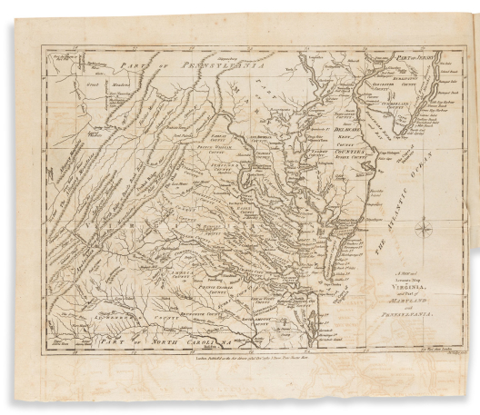


139
(periodicals.)
The Political Magazine and Parliamentary, Naval, Military, and Literary Journal, for the Year MDCCLXXX [and] MDCCLXXXI.

London: J. Bew, 1780-1781
35 engraved folding maps by John Lodge, 8 engraved plates (lacking portrait of Major Andre). 2 volumes. 8vo, contemporary vellum over marbled boards with gilt morocco spine labels, moderate wear, modern shelf labels to each spine; maps with offsetting and occasional short margin stain, a few with repairable fold splits.
“Scarce. One of the most interesting and desirable of the English periodicals published during the American Revolution. It is largely devoted to accounts of naval and military transactions and the progress of the war in the American Colonies” – Anderson catalog, 1915.
Maps and plans include: Gibraltar; Charleston, South Carolina and the attack on Fort Sullivan; Brest, France; The English Channel; South Carolina and Georgia; South America; Cadiz; Jamaica; East Indies; [New England Military Operations (top left title-panel only, most of map not present)]; Rhode Island; North Carolina with the field of battle between Cornwallis and Gates; Virginia/Maryland/Pennsylvania; The Netherlands; Islands of Jersey, Guernsey, etc.; East Indies/Spice Island/Philippines; Anguilla/St. Martin/St. Barts/St.Kitts, etc.; Cape Fear River, North Carolina; Straits of Gibraltar; Southern India/Ceylon; Cape of Good Hope; Venezuela/Brazil; Florida/Gulf of Mexico; West Indies; Cape Verde Islands/Senegal coast; Western Africa; St. Lucia/Martinique; North Sea; Island of Minorca; Mauritius/Bourbon (Reunion) Island; Atlantic Ocean; Chesapeake Bay/Seat of War; New York Bay/Manhattan; Mediterranean Sea; Toulon; Barbados.
Plates include: General fortification diagrams; military utensils; Benjamin Franklin; General Burgoyne; Newgate Prison/Simsbury Mine diagram.
Estimate
$1,000 – $1,500


140
(philippines.) u.s. coast and geodetic survey; after p. jose algue.
Atlas de Filipinas / Atlas of the Philippine Islands, Special Publication No. 3.

Washington, D.C.: Government Printing Office, 1900
30 color-printed lithographed maps. Small folio, 14½x13 inches, publisher's worn gilt-blocked cloth; several maps with Department of the Navy blind stamp; bookplate: "Ship's Library, U.S.S. Galveston".
Estimate
$200 – $250


141
(railroads.)
Group of 5 detailed blueprint booklets of Illinois Central Railroad Company lines.

Chicago, 1920
Oblong 8vo format, 4x9 inches each; original wrappers fastened at left with blue paper spine cover and heavy date stamp; minor wear.
Nice cluster of condensed profile route guides to several Illinois Central Railroad divisions:
Indiana Division. 104 pages.
Kentucky Division. 107 pages.
Chicago Terminal. 34 pages.
New Orleans Terminal Division. 28 pages.
Chicago, Memphis & Gulf R.R. 12 pages.
Estimate
$500 – $750


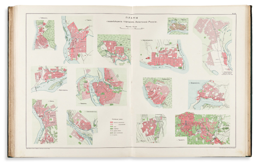


142
(russia.) glinka, grigoriy vyacheslavovich.
Aziatskaya Rossiya Atlas (Atlas of Asiatic Russia).

St. Petersburg, 1914
Atlas volume only. Chromolithographed title-page in gold and silver, 72 chromolithographed statistical maps, tables and plates on 56 sheets (mostly double-page, one folding). Large folio, 21x16½ inches, publisher’s lightly worn morocco-backed green cloth boards embossed and gilt with Russian Imperial eagle; internally clean.
Estimate
$2,000 – $3,000


143
(geography in russian.) a.f. marks.
Bol’shoy Vsemirnyy Nastol’nyy Atlas Marksa (Marks’ Large Desktop Atlas of the World).

St. Petersburg, [1909] 1910
55 double-page chromolithographed mapsheets. Folio, 17½x12 inches, publisher’s gilt morocco-backed green pictorial cloth boards, quite fine; minor foxing to title-page, otherwise clean.
An exceptional copy of this rare pre-revolution Russian atlas of world geography.
Estimate
$1,000 – $1,500


144
(siberia.) jean-baptiste chappe d’auteroche.
Voyage en Siberie.

Paris, 1768
Atlas volume only. Engraved frontispiece and 30 engraved maps, charts and elevation plans (some folding, several with original hand-color in outline). Large folio, 26x20 inches, nineteenth-century cloth-backed marbled boards, moderately worn; occasional foxing or soiling but generally nice.
Estimate
$1,500 – $2,000


145
(western exploration.) william h. emory.
Notes of a Military Reconnoissance from Fort Leavenworth, in Missouri, to San Diego, in California.

Washington, D.C., 1848
416 pages, 43 lithographed plates (including 3 battle plans and 12 botanicals), large folding lithographed map tucked in custom rear pocket. 8vo, 9x5½ inches, publisher's cloth with partial printed spine label, moderate wear, map pocket split at lower seam; scattered dampstain and foxing, large map with some browning but generally good. 30th Congress, 1st Session, Senate Exec. Doc. 7.
Estimate
$400 – $600


146
Akerland, e.
Geographisk Hand-Atlas.

Stockholm, circa 1840
Double-page letterpress title/index leaf and 21 double-page engraved maps on “C&I Honig” watermarked laid paper. Folio, 15x10 inches, contemporary calf-backed marbled boards, light wear; original hand-color; internally quite fine.
First-rate copy of an uncommon atlas with the maps in virtually pristine condition. An extraneous lithographed Swedish map of the northern celestial sky guarded in ahead of the beginning map.
Estimate
$1,800 – $2,200

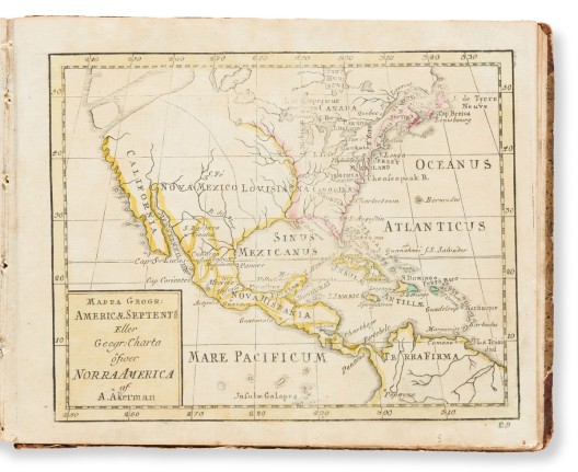


147
Akerman, anders.
Atlas Juvenilis.

Uppsala and Stockholm, 1774
Engraved title/index leaf, and 30 full-page miniature engraved maps with original outline hand-coloring. Oblong 8vo, 6x8 inches, contemporary calf-backed speckled paper-covered boards, light wear; generally clean with no major flaws.
together with: Kort Forklaring Ofver Atlas Juvenilis. (Text explanation to accompany the atlas). [iv], 192 pages. 8vo, matched binding, moderate wear.
Second (expanded) edition of Akerman’s school geography, complete in both matching volumes.
Estimate
$500 – $750


148
Baeck, elias; after alexis-hubert jaillot, and others.
Atlas Geographicus Oder Accurate Vorstellung der Gantzen Welt.

Augsburg: [1710]
Engraved folding allegorical frontispiece, double-page engraved title, dedication, index, and 26 (of 30) double-page engraved maps and celestial charts. Small 4to, 7¾x7¼ inches, contemporary calf with a small bird tool and title blocked in blind to front board, small erosion at upper spine and other light wear but generally attractive; contents with minor finger soiling and other small scattered stains, contemporary ink titles in German and French added to upper margin of each map, 9 maps hand-colored in outline.
Lacking numbers: 6 Europe, 13 England and Ireland, 15 Italy, and 20 Turkey in Europe.
Estimate
$700 – $1,000


149
Bradford, thomas gamaliel.
[Comprehensive Atlas. Geographical, Historical & Commercial.]

Boston, 1838 (date from binding label)
78 full-page engraved charts, diagrams and maps with original hand-color in outline, lacking title and frontis. Small folio, 13x10½ inches, well-worn publisher’s gilt roan over marbled boards with printed paper title label to upper cover; foxing throughout, occasional edge tears, map of Mexico and subsequent text leaf torn and lacking upper half; “Wyoming Historical Geological Society, Wilkes-Barre” ink stamp to contents leaf.
Noteworthy for its inclusion of the first atlas map to show Texas as a separate republic.
Estimate
$1,800 – $2,200


150
Cellarius, christoph.
Geographia Antiqua: Being a Complete Set of Maps of Ancient Geography.

Dublin: Ann Watson, circa 1820
33 full-page engraved maps. Oblong folio, 10x14 inches, publisher’s marbled wrappers with printed title-label to upper cover, well-worn and rebacked; several maps with graphite annotations.
Estimate
$400 – $600


151
Fisher, richard swainson.
A General Geography and History of the World.

New York: J.H. Colton, 1857
842; 895 pages, 5 lithographed folding maps by Colton. 2 volumes. 8vo, 8½x6 inches, red contemporary calf over cloth, gilt spines, some wear and staining but sound; foxing throughout, bookplates. Apparently rare.
Estimate
$200 – $300


152
Melish, john.
A Military and Topographical Atlas of the United States.

Philadelphia: G. Palmer, 1813
5 engraved folding maps with original wash and outline hand-color, 3 full-page engraved plans. 8vo, 8½x5½ inches, plain modern binding, maps extended on later wide guards; pigments oxidized and offset but stable, folds variously repaired with film-tape to recto and verso, text and plans browned with age.
Estimate
$4,000 – $6,000


153
Montague, william henry.
A New and Universal History of England, from the Earliest Authentic Accounts, to the End of the Year 1770.

London: J. Cooke, [circa 1771]
2 volumes in one. [iv], 570; [ii], 520, [24] pages illustrated with 106 engraved plates and 11 engraved maps. Folio, 14½x9½ inches, worn contemporary tree calf, rebacked; moderate foxing, 2 leaves of final index with large closed tears.
Estimate
$400 – $600


154
Münster, sebastian.
Cosmographiae Universalis.

Basel, 1554
Lacking double-page maps, plans and town views, but otherwise nearly complete text with profuse woodblock illustration. 4to, 12x8½ inches, later liturgical manuscript vellum with gilt morocco spine label; some dampstaining; sold as is.
Estimate
$700 – $1,000


155
Stackhouse, thomas.
An Universal Atlas; Being a Set of Maps, to Illustrate Ancient and Modern Geography.

London, [1782] 1783
38 (of 39) full-page engraved maps in strong original hand-color (lacking final map of the Holy Land). Large folio, 20½x17 inches, later quarter calf, worn; maps numbered in ink at upper corners, offset and verdigris transfer to facing pages but overall nice with wide margins and no major faults; 1782 title-page with 1783 imprint slip pasted on.
“Calculated to facilitate the study of geography; to make that science more extensively known; and thereby to render history, both ancient and modern, more intelligible and useful.”
Estimate
$1,200 – $1,500


156
Tanner, henry schenck.
The American Traveller; or Guide Through the United States.

Philadelphia, 1836
144 pages, hand-colored engraved folding map, 4 engraved view plates, and 4 double-page engraved city plans. 8vo, 6x3½ inches, original cloth boards with printed paper title-label to upper cover, worn and serviceably rebacked; minimal foxing, folding map with small fold separations.
Estimate
$400 – $600


157
Young, james hamilton, engraver; after conrad malte-brun.
A New General Atlas, Exhibiting the Five Great Divisions of the Globe, Europe, Asia, Africa, America & Oceanica.

Philadelphia: Grigg & Elliot, 1832
Letterpress title-page and index, 40 hand-colored full-page engraved maps (lacking Eastern Hemisphere but Western Hemisphere in duplicate as erroneously bound). 4to, 11¼x9½ inches, publisher's half roan over marbled boards with printed paper title label to upper cover, worn, inner hinges strengthened; maps generally sharp and clean.
Estimate
$400 – $600
Plate & Illustrated Books


158
(aeneid.) luigi ademollo.
Énéide Dessins Bas-Reliefs au Trait.

Paris, circa 1830
4 letterpress pages of condensed verse in French and 30 lithographed plates (including pictorial title) illustrating scenes from Virgil’s epic tale of mythological Trojan hero Aeneas. Large oblong folio, 10½x22 inches, original cloth-backed marbled boards, worn and rebacked preserving most of original spine, “Morel Poupeterie” ticket to front pastedown; staining, foxing, and foredege repairs. OCLC locates only 4 copies.
Estimate
$400 – $600


159
(belle époque etchings.)
Compilation of 14 themed “Series” published by L. Joly, many of which tamely erotic in nature.

Paris, circa 1880’s to 1890’s
4to, 12x9 inches, contemporary French morocco over marbled boards, gilt spine with tools of a hand fan and danseuse, top edge gilt, other edges uncut, moderate wear; plates generally clean; bookplate of Sim W. Crabill.
Henri Boutet. Types de Parisiennes. Drypoint title-page in duplicate and 7 drypoint plates on laid paper.
Henri Boutet. Types de Parisiennes… 2nd Serie. Drypoint title-page in duplicate and 7 drypoint plates on laid paper.
Ladislas Loery. Suite de Pointes Seches. Drypoint title-page in duplicate and 6 drypoint plates on laid paper.
Dachery. Pointes Seches. Drypoint title-page in duplicate and 8 drypoint plates on laid paper.
Henry Somm. Six Pointes Seches. Drypoint title-page in duplicate and 6 drypoint plates on laid paper.
Joseph Apoux. Danseuses. Drypoint title-page in duplicate and 5 drypoint plates on laid paper.
Joseph Apoux. Le Zodiaque. Drypoint title-page in duplicate and 5 drypoint plates on laid paper.
Joseph Apoux. Les Etoiles. Drypoint title-page in duplicate and 5 drypoint and aquatint plates on laid paper.
Joseph Apoux. Sorcieres. Drypoint title-page in duplicate and 7 drypoint and aquatint plates on laid paper.
Anon. Six Caprices a l’eau-forte. Aquatint and etched title-page in duplicate and 6 aquatint and etched plates on laid paper.
Joseph Apoux. Les Peches Capitaux. Drypoint title-page in duplicate and 7 drypoint and aquatint plates on laid paper.
Joseph Apoux. Fantaisies Lunaires. Drypoint and aquatint title-page in duplicate and 5 drypoint and aquatint plates on laid paper.
Jean Ulysse-Roy. La Journee d’Une Parisienne. Etched title-page in duplicate and 6 etched and aquatint plates on laid paper.
Joseph Apoux. Pointes Seches. Drypoint title-page in duplicate and 7 drypoint plates on laid paper.
Estimate
$2,500 – $3,500

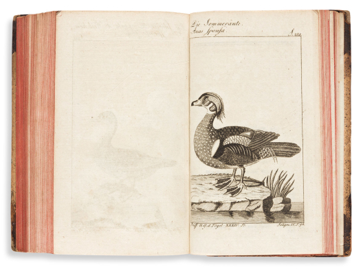

160
(birds.) bernhard christian otto; after buffon.
Herrn von Buffons Naturgeschichte der Vogel.

Berlin, 1807-1808
[33rd & 34th volumes bound in one]. Engraved frontispiece, 2 engraved titles, and 67 engraved plates of geese and ducks. 8vo, 7½x4½ inches, contemporary calf-backed speckled paper boards with gilt morocco spine labels, light wear; occasional edge staining.
Estimate
$200 – $250


161
(botany.) botanical fine art weekly.
Wild Flowers of America.

New York: G.H. Buek & Co., 1894
288 chromolithographed flowers on 144 plates, descriptive text on verso. Oblong 4to, 8½x12 inches, publisher’s gilt-blocked cloth boards, rebacked and recornered; occasional staining.
Estimate
$200 – $250


162
(botany.) ramon de la sagra.
Historia Fisica, Politica, y Natural de la Isla de Cuba… [Botanica].

Paris, circa 1845
Atlas volume only. Half-title and 122 engraved plates (20 hand-colored). Folio, 16x11 inches, lightly worn later half calf; worm track throughout varying in seriousness.
Estimate
$300 – $400


163
(botany.) michaux, f. andrew; and nuttall, thomas.
The North American Sylva. [and] The North American Sylva… Not Described in the Work of F. Andrew Michaux.

Philadelphia: Rice, Rutter & Co., 1865
Engraved portrait frontispiece, 156 hand-colored engraved plates, and 121 (1-29, 5 bis, 10 bis, 32-121) hand-colored lithographed plates. 5 volumes. 8vo, uniform publisher's half morocco, light wear at extremities; intermittent foxing.
Estimate
$1,200 – $1,800


164
(botany.) philip miller.
The Gardeners Dictionary: Containing the Methods of Cultivating and Improving the Kitchen, Fruit and Flower Garden.

London, 1737
Engraved frontispiece, text engraving, and 2 engraved plates. Folio, 13½x9 inches, contemporary calf rebacked with replacement gilt spine label; light dampstaining; Art Nouveau bookplate of the Horticultural Society of New York.
Estimate
$200 – $250


165
(botany – africa.) john hanning speke; james augustus grant.
The Botany of the Speke and Grant Expedition, an Enumeration of the Plants Collected During the Journey … from Zanzibar to Egypt.

London: Taylor and Francis, 1872-1875
3 parts in one, Volume XXIX of The Transactions of the Linnean Society of London. 190 pages, color-tinted lithographed map and 136 lithographed plates after Walter Hood Fitch. 4to, 11½x9 inches, contemporary cloth-backed plain boards with paper spine labels, boards separated, block and spine cracked into three sections; contents very clean; oval ink stamps of Stoke on Trent Free Library to prelims and several plates.
Estimate
$100 – $150


166
(botany – orchids.)
Lindenia: Iconographie des Orchidees (2nd Series, 15th Volume).

Ghent, 1899
48 chromolithographed plates of orchid varieties (DCLXXIII-DCCXX). Folio, 14½x11½ inches, 20th-century half morocco by Winstanley, top edge gilt, other edges uncut; in general very bright and clean.
Estimate
$700 – $1,000


167
(chapbooks.)
Group of 5 nineteenth-century miniature American children’s books.

Vp, vd
12mo-16mo format, printed paper wrappers, wood-engraved illustrations; generally good condition.
Birth-Day Present; from an Affectionate Friend. New Haven: Sidney Babcock, 1833.
The Little Sisters; or Emma and Caroline. New Haven: Sidney Babcock, circa 1840.
Plain Things for Little Folks; Seasoned with Instruction both for the Mind and the Eye. New Haven: Sidney Babcock, 1838.
Little Rhymes for Little Readers. Northampton, [MA]: J.H. Butler,1835.
The Children in the Wood. New York: Mahlon Day, circa 1835.
Estimate
$100 – $150


168
(chirography.) thomas astle.
The Origin and Progress of Writing, as Well Hieroglyphic as Elementary.

London, 1784
31 engraved plates (3 leaves printed recto/verso, 9 folding, several with hand-color). 4to, 11¼x9½ inches, modern quarter calf, internal case split at center; plates offset, later sheet of typeface tipped to verso of Hh2.
Estimate
$200 – $250


169
(chirography.) françois nicolas bédigis.
l’Art d’Ecrire, Demontre par des Principes Approfondis, et Developpes dans Toute Leur Etendue.

Paris, 1768
Engraved portrait frontispiece, viii, 20 pages, and 15 full-page engraved plates decoratively illustrating the techniques of “expert writer” Bédigis. Folio, 20x13 inches, modern light blue paper-covered boards; light foxing and dampstain, one text leaf with lower corner replaced; priced and signed by Bédigis in ink calligraphy at lower title-page. OCLC locates three copies, no auction records.
Estimate
$500 – $600


170
(costume – travel.) jules ferrario.
Le Costume Ancien et Moderne. [Asia - Volume 1].

Milan, 1815
86 (of 87) hand-colored aquatint and engraved plates of subjects relating to China, Formosa, Korea and Japan (including frontis and folding map of Asia, lacking folding world map). 4to, 14x10 inches, modern quarter leatherette over marbled boards; plates with library blindstamps but otherwise clean with bright original colors.
Estimate
$400 – $600


171
(costume – travel.) robert kerr porter.
Travelling Sketches in Russia and Sweden During the Years 1805, 1806, 1807, 1808.

London: John Stockdale, 1813
37 (of 41) aquatint plates, most hand-colored or tinted, 3 folding. 2 volumes. 4to, 11¼x9 inches, contemporary half roan with “Mr. Dhunjibhai Sorabji Book-binder, Fort Bombay” binder’s tickets, rebacked; occasional stains and repairs.
Estimate
$250 – $300


172
(costume – travel.) francis b. spilsbury.
Picturesque Scenery in the Holy Land and Syria, Delineated During the Campaigns of 1799 and 1800.

London: B.R. Howlett for Thomas M’Lean, 1819
18 (of 19) hand-colored aquatint plates. Folio, 18½x13½ inches, original half roan with gilt morocco title label to upper cover, boards detached; occasional minor foxing, one plate with short mended tear; "JWhatman Turkey Mills/1817" watermark throughout; bookplate of Peter Gerard Stuyvesant to front pastedown.
Estimate
$500 – $750


173
(crime tabloids.)
The Illustrated Police News, Law-Courts and Weekly Record.

Boston, 1892-1893
Bound group of 28 profusely illustrated 16-page American periodical issues dating from the weeks of November 5, 1892 to November 4, 1893. Folio, 16x11 inches, contemporary calf-backed boards, worn; papers with minor wear.
Illustrated newspaper “reporting” on all manner of sensationalized criminal mischief and felony, domestic deceit, drunkenness, bawdy entertainment… and boxing.
Estimate
$800 – $1,200


174
(design.) arthur seemann.
Japanische Farbeschablonen. Hundert Muster Kleineren Formates in Originalgrosse.

Leipzig, 1899
100 chromolithographed plates of Japanese stencil designs. Folio, 16½x12 inches, contemporary morocco-backed marbled boards, spine well worn; plates generally fine.
Estimate
$300 – $400


175
(design.) c.j. richardson.
Studies of Ornamental Design.

London: John Weale, 1851
2 tinted lithographed title-pages, 2 lithographed calligraphy dedications, 7 text pages within decorative lithographed borders, and 16 lithographed plates (including frontis, several tinted or in colors). Large folio, 22¼x17¼ inches, modern green cloth; Franklin Institute Library stamp to each sheet.
Estimate
$200 – $250


176
(dust jackets.)
Collection of approximately 170 twentieth-century novel covers.

Vp, vd
8vo format; for decorative purposes, front panels only, some with spines; kept in two three-ring binders.
Estimate
$150 – $200


177
(dutch wars.)
Des Verunruhigten Holländischen Löwens. Siebenter Theil.

[Nuremberg], 1676
Engraved emblematic folding frontispiece, [vii], 452 pages, 6 engraved folding maps, 2 engraved portrait plates. Bound with: Josaphat der Vierdte König in Juda und Benjamin mit Seiner Regierung. 260 pages. 12mo, contemporary vellum with manuscript paper spine label, light age wear; library ink stamp to title.
Estimate
$200 – $250


178
(games.)
Group of 3 nineteenth-century European children’s games.

Vp, vd
Joseph Lartschneider. Schimmel-Spel. 5 hand-colored engraved cards, six bone dice; original green paper-covered card box with printed paper title-label (6x4 inches); light wear.
Das Lustige Tänzerpaar mit Veranderungen / The Jovial Dancing Couple with Transmutations. 5 hand-colored lithographed sheets heightened with gum arabic, dissected into 23 (of 24) interchangeable metamorphic cards; original divided card box with hand-colored lithographed title pasted on (7¾x6¼ inches); light wear.
[No title, no maker.] Dissected sections of 3x3 inch hand-colored lithographed faces of people and animals; appears to be significantly incomplete but still able to be assorted to form a good number of comical combinations; original card box with lithographed pictorial top (3¼x3¼ inches); light wear.
Estimate
$300 – $400


179
(games – ornithology.) a.j. fouch company.
Sectional Birds.

Warren, PA, circa 1915
Charming set of 8 lithographs on card, each segmented into four parts and effecting a titled image when assembled. Each card 5½x7 inches when joined; light age toning, original card box with printed paper label, well-worn but intact.
Estimate
$250 – $300


180
(hastilude – jousting.) friederich schlichtegroll.
Turnier Buch Herzogs Wilhelm des Vierten von Bayern von 1510 bis 1545.

[Munich, 1817]
Part 5 (of 8) only; pages 17-20 and 4 double-page lithographed plates on two sheets joined, printed in gold, silver, and black and finely hand-colored, each with descriptive text leaf (XVII-XX). Oblong 4to, 11x14 inches, lightly worn printed paper wrappers; uncut but left and right margins of each plate notched to a lithographed registration line, light offsetting.
Scarce, complete or in any form, the exquisite illuminated lithographs by Theobald and Clemens Senefelder are rather pleasing here preserved in the original individual part wrappers.
Estimate
$1,000 – $1,500


181
(japan – cookery.)
Two albums of traditional Japanese confectionary design and recipes.

Japan, vd
Kashi Moyo. 40 pages with scores of woodblock illustrations. Oblong 8vo format, 7x9¾ inches, silk-covered boards with printed title label, spine defective; minor soiling. Meiji 34 (1901).
Shinnen Ka-Cho. 16 pages of offset color-printed illustrations. Oblong 8vo format, 7x9½ inches, cord-stitched printed pictorial wrappers, minor wear. Taisho 1 (1912).
Estimate
$700 – $1,000


182
(japan – cookery.)
Early manuscript scroll of Japanese cuisine presentation.

Japan, circa 1800
Ink, watercolor and gouache on 8 sheets of thin paper joined; 5¾x132 inches overall; minor wear at terminal edge, else very well preserved.
Delicately illustrated arrangements of sushi, soups, sake, sweets, pickled items, and other Japanese culinary traditions.
together with: Hayami Kon Date Shu. 2 double-page and 2 full-page woodblock illustrations, 162 pages of recipes. Oblong 8vo format, 4¾x7 inches, fairly worn original embossed blue paper wrappers with printed paper label. Mid-nineteenth century.
Estimate
$1,000 – $1,500


183
(japan – cookery.)
Manuscript albums of food preparation and etiquette.

Japan, vd
Illustrated guide to butchering fowl. 43 pages of instructional ink sketches on the subject. Oblong 8vo format, 6x8½ inches, cord-stitched plain wrappers; scattered worm track, staining at foredge. Mid-19th century.
and:
3 volumes. Ink and watercolor; 8vo format, 10x6½ inches; stitched wrappers, moderate wear. Two volumes on table manners, the third volume nicely illustrated with shellfish preparation and table display. Meiji 33 (1900).
Estimate
$1,000 – $1,500

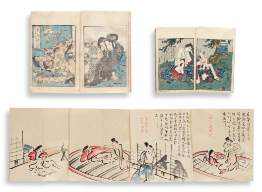


184
(japan – erotica.)
Group of mid-to-late nineteenth-century shunga.

Japan, vd
Hand-painted manuscript shunga in a Toba-e Manga style. 36 amusing amatory scenes in ink and watercolor on 41 sheets of laid paper joined, 8x263 inches fully extended; folding down into patterned silk self-wrappers with printed title label, all edges gilt; minor rubbing. Meiji period.
2 volume medicinal guide to sex; embossed orange wrappers with 5 color-printed woodblock prints (3 double-page), 8¾x6 inches, later stitching, marginal worm track. Circa 1840.
Plain wrappers with 3 color-printed woodblock scenes (one double-page), 20 pages of text. 7x4¾ inches, later stitching, moderate wear. Circa 1840.
Three loose color-printed woodblock prints. 3¾x4¾ inches each. Circa 1900.
Estimate
$800 – $1,200


185
(japan – erotica.)
Group of three small-format woodblock shunga albums.

Japan, circa 1840
Approximately 30 color-printed woodblock panels of sexual nature coupled with inset views along the Tokaido Road. 7x4½ inches each, two with pictorial wrappers, the other patterned paper, all well worn.
Estimate
$700 – $1,000

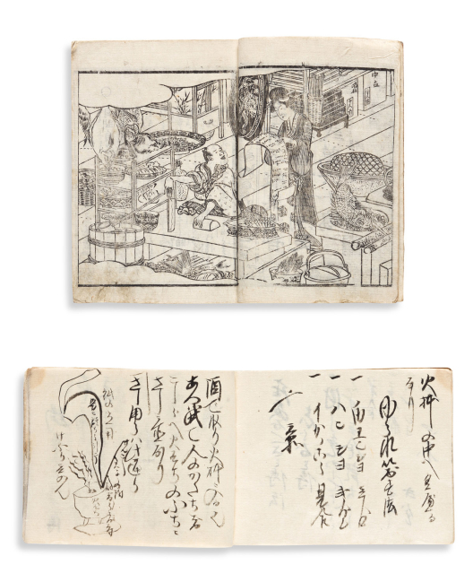


186
(japan – sake.)
Sake brewer’s manuscript recipe notebook.

Japan, circa 1820
Oblong 8vo format, 4¾x6½ inches, cord-stitched self-wrappers, minor wear and staining.
Scarce nineteenth-century brewer's notebook containing recipes and secrets for preparing varieties of sake, including enmeishu zukuri, thought to extend a person's lifespan, and mirinshu, traditionally used in cooking.
together with: Meitei Kishitsu (The Character of a Drunk). Several woodblock illustrations. 8vo format, 7x5 inches, moderately worn orange paper wrappers with printed title label. Circa 1845.
Estimate
$800 – $1,200

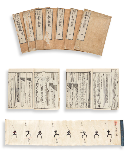

187
(japan – samurai.)
Shin Tou Bengi.

Japan, Kaei 4 (1851)
9-volume study on Japanese swordsmithing, well-illustrated with many double-page woodblock illustrations and diagrams. 8vo format, 9½x7 inches, moderately worn original embossed tan paper wrappers with printed paper labels, later stitching; contents generally fine with an occasional minor worm track.
together with: Mutsuryu Kodachi No Maki. Fine hand-drawn scroll illustrating 10 sword-fighting positions in a delightfully naïve archaic style. Black and red ink on 3 sheets of thin paper joined; wooden roller dowel and stamped blue paper terminal edge; 6x48½ inches overall; minor wear only. Japan, 17th-century.
Estimate
$1,500 – $2,500


188
(japan – storytelling.)
Two kamishibai sets, both telling the tale of the Chushingura, or Ronin Samurai.

Japan, Showa 18 (1943) and Showa 19 (1944)
Each story comprising 20 offset color-printed cards with original printed outer envelope; both groups 15½x10½ inches; light general wear but overall nice condition.
Starkly illustrated kamishibai street-performance plates implementing a historical narrative of the 47 Ronin as wartime propaganda.
Estimate
$400 – $600


189
(japan – textile design.)
Kokon Ontorihodoki Moyo.

Kyoto, Showa 8 (1933)
Catalog of 53 lithographed kimono design plates. Small folio format, 13¼x9¼ inches, original stitched silk wrappers with printed title label, endcaps consolidated in orange; moderate foxing.
together with: A fine collection of many hundred kimono fabric sample swatches tipped to album leaves. 9 volumes. 8vo format, various stitched wrappers. Japan, circa 1930's.
Estimate
$300 – $400


190
(japan – theater design.)
Manuscript notebook of traditional Noh theater set and costume design.

Japan, Tenmei 3 (1783)
Approximately 200 pages of detailed manuscript notes profusely illustrated with ink and watercolor drawings. Oblong 8vo format, 5¼x8 inches, later silk wrappers, light wear; leaves skillfully reinforced on verso stabilizing scattered worm track.
together with: Collection of 8 large 19th-century ink wash mask illustrations. 15x10½ inches, stitched at upper edge.
Estimate
$700 – $1,000


191
(japanese / russian trade relations.)
Manuscript report of Imperial Russian Navy Admiral Yevfimiy Putyatin’s diplomatic visit to Japan.

Japan, Kaei 7 (1854)
27 manuscript pages including a sketch of Putyatin’s flagship Diana, and a map of her entrance into Osaka Bay. 8vo format, 10x7 inches, cord stitched; small amount of worm track.
Russian Admiral Yevfimiy Vasilyevich Putyatin played an instrumental role in negotiating commercial relations between Japan and Russia. The Treaty of Shimoda, signed in 1855 between the two empires, opened Japan’s ports to Russian commerce.
In late 1854 Putyatin arrived with his squadron at Osaka Bay causing a great panic among the Shogunate, as related in this contemporary document. The Russians were shortly thereafter directed on to Shimoda for a more comfortable setting to hold diplomatic negotiations. On December 23, 1854, the day prior to a planned meeting with Shogunate officials, a massive earthquake hit the area causing a great tsunami which destroyed the Russian ships. Local Japanese tradesmen worked together with the Russians to build a new boat large enough to sail Putyatin and his crew back to their homeland. This was the first western-style ship built in Japan and an early instance of Japanese learning western technology. The vessel, dubbed “Heda”, was completed in a matter of months and after finalizing the trade treaty in spring 1855, the Russians dispatched for home.
together with: Woodblock report of the Treaty of Amity and Commerce between Japan and Russia. 44 pages, 8vo format, 9x6¼ inches, plain wrappers; small amount of worm track. [1858].
Estimate
$800 – $1,200


192
(japanese album.)
Photograph album with hand-painted silk mounts.

Japan, circa 1900
18 silk-covered passe-partout window mounts hand-painted in gouache and watercolor. 4to format, 10¾x8½ inches, inlaid pictorial lacquer boards backed with decoratively tooled and colored roan spine, small chips and minor wear to the exterior but needs recasing; mounts with minimal foxing.
Estimate
$200 – $250


193
(myanmar / burma – sketchbooks.)
Group of 3 albums containing ethnographic watercolor portraits of local peoples, market scenes, and festivities of the Shan State’s Kengtung region.

Kengtung, Shan State, Burma (Myanmar), 1908
"Kengtung Types" - 2 volumes. 34 pages of ink and gouache drawings. Oblong 8vo, 7½x11½ inches, original slightly worn blue cloth; typewritten titles pasted to upper covers (one label partially lost), typewritten index and explanation sheets pasted to inside covers; minor scattered soiling.
"Kengtung Occasions" - Book II only. 30 pages of ink and watercolor drawings. Oblong 8vo, 7¼x10¼ inches, original calf-backed cloth boards, spine defective; typewritten title pasted to upper cover (partially torn), typewritten index and explanation sheet pasted to inside cover; minor scattered soiling.
“These pictures were drawn at my request in 1908 by a Hkön artist of Kengtung, the sketch books being provided.” - from the typewritten title-labels with ink signature, possibly reading “Ri’d [Richard] Phillimore.”
Wonderful bespoke souvenir-type albums for an early 20th-century visitor to Kengtung in the eastern region of Shan State, Myanmar (formerly Burma). Each plate is captioned in Shan script and corresponds with the English explanation on the typed index leaf.
The “Types” albums depict tribal villagers and hill people in various colorful dress with personal effects such as smoking pipes, parasols, weapons and hunting instruments, as well as several representations of goods production and farming.
The drawings in the “Occasions” volume are generally more thematic, showing scenes of festivals, processions, and ceremonies, lighting fireworks, various sellers of cigars, liquor, noodle soup, and fruits at market, musical entertainment, animal hunting, and other exotic portrayals.
Estimate
$3,000 – $4,000


194
(new york city.) charles b. hall.
Old New York. Hall’s Views and Portraits (title from spine).

New York, circa 1880’s
50 etched plates: 35 views of colonial New York, 15 portraits of politicians and other figures; all captioned and signed by the artist in graphite. 4to, 11x8½ inches, contemporary half morocco by Bradstreet’s, spine a bit worn and sunned; plates clean.
Estimate
$2,000 – $3,000


195
(paper samples.) house of kajinoha.
Japanese Paper.

Kyoto, 1960
Over 950 leaves of different stocks and patterns designated for various uses in 10 sections. Thick oblong 4to format, 7¼x10¼ inches, publisher’s embossed boards, front cover detached, lower spine cap damaged; internally fine.
Estimate
$200 – $250


196
(photography.)
Album of over 100 mounted albumen photographs, some of the tourist genre, but many showing officers and international forces involved in the suppression of the Boxer Rebellion.

Vp, circa 1900
Oblong 4to format, 10½x13½ inches, worn cloth covers; card-stock leaves with cloth edging once forming a leporello but nearly all separated, scattered soiling.
Estimate
$300 – $400

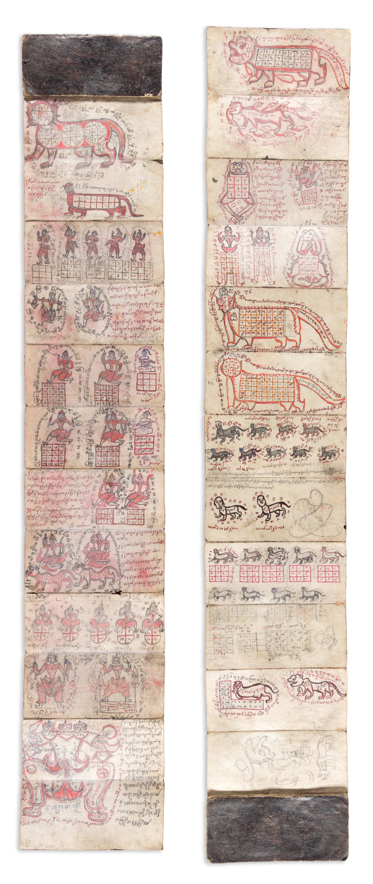

197
(pustaha.)
Batak shaman manuscript of magic, medicine, and ritualistic knowledge.

Indonesia, 20th-century
Ink, gouache and graphite on heavy handmade paper; 90 panels recto/verso in leporello format with card self-wrappers, 8¼x166 inches fully extended; light soiling and age wear, minor worm tracks.
Estimate
$400 – $600


198
(russia.) st. petersburg picturesque review.
Album of Russian Life and Nature in Pictures in Watercolors Peinted [sic] by the Russian Artist N.N. Karazin.

St. Petersburg: S. Dobrodeew, 1892
English title-page printed in gold, 15 chromolithographs after Karazin mounted to black cards with gold-printed ruling and English captions. Oblong 4to, 9½x14 inches, publisher's cloth with chromolithographed pictorial title-plate pasted to upper cover, rebacked and re-guarded with sympathetic cloth, small scrapes and stains; mounts with minor edge wear, plates fine; gift inscription on pictorial stationary from U.S. Consulate General to Russia, J.M. Crawford, to Dr. Thomas DeWitt Talmage pasted to inside front cover.
A vestige of appreciation for one man’s kindness: presentation copy of an uncommon album from U.S. Russian Consulate General J.M. Crawford, on behalf of its publisher, to Reverend Dr. Thomas DeWitt Talmage who in 1892 orchestrated the delivery of a ship’s-load of food and relief aid to Russian provinces during their period of great famine. The American clergyman’s humanitarian effort was received with utmost appreciation and his visiting circle were given an enthusiastic reception by the Russians, culminating in an audience with Tsar Alexander III.
The inscription reads: “July 17, 1892. Dear Dr. Talmage: The Picturesque Review of St. Petersburg desires me to offer you the accompanying album of Russian scenes as a petit souvenir of your humane mission to this country. Very sincerely yours, J.M. Crawford”.
The fine vernacular chromolithographs are after oil paintings by Russian military officer and artist Nikolay Nikolaevich Karazin.
OCLC locates a single copy of the album, Yale University. See T. DeWitt Talmage, His Life and Work, pages 199-224 for a lengthy description of Talmage’s Russian experience.
Estimate
$1,500 – $2,500


199
(sketchbooks.) alma bertha bertsch; and/or marguerite bertsch.
Album of approximately 60 juvenile pen and ink drawings.

[New York City, 1897]
4to, 10¾x8¾ inches, printed pictorial album covers, spine rebacked with plain paper and defective; sketches either loose or mounted to brittle album leaves, scattered offset and trimming.
“Album of 1897” in ink on front pastedown: the drawings are generally skillful for a child’s hand and include portraits, architecture, arbor, still-life, fashionable hats, furniture and home furnishings, nursery rhymes, seasonal allegories, birds, animals, and other late 19th-century subjects.
The names of Alma-Bertha Bertsch and Margarethe [sic] Bertsch appear at separate places in large stylized calligraphy. The two sisters were born in New York City in 1885 and 1887 respectively. Their younger brother, Karl Alfred was born in 1889; one of the drawings depicts an age-appropriate boy wearing a sailor’s uniform and cap lettered “Karl”. Alma Bertha spent her career as an educator and real estate broker in New York City; Marguerite also started off as a school teacher but for a brief period in the mid-to-late 19-teens she enjoyed an occupation as a screenwriter and silent film director with Vitagraph Studios, a prominent early 20th-century Brooklyn production company.
Estimate
$300 – $400


200
(sketchbooks.)
Group of 4 nineteenth-and-twentieth-century sketchbook albums.

Vp, vd
Together over 100 pages of ink, graphite, and watercolor drawings of vernacular persuasion. 8vo format, some wear.
Estimate
$200 – $250


201
(sporting.) captain william cornwallis harris.
The Wild Sports of Southern Africa; Being the Narrative of a Hunting Expedition from the Cape of Good Hope, Through the Territories of the Chief Moselekatse, to the Tropic of Capricorn.

London: Pelham Richardson, 1844
26 hand-colored lithographed plates (including frontis and additional title), lithographed folding map. Royal 8vo, 10x7 inches, publisher's pictorial-gilt red cloth, rebacked preserving original spine; moderate foxing, contemporary ink inscription to front end leaf.
Estimate
$400 – $600


202
(sporting.) captain thomas williamson; and samuel howitt.
Oriental Field Sports; Being a Complete, Detailed, and Accurate Description of the Wild Sports of the East.

London: Edward Orme, 1807
2 etched frontis-plates, 40 etched and aquatint plates with fine original hand-coloring. 2 volumes. 4to, 12½x9 inches, needs binding; moderately foxed throughout; armorial bookplate of Robert Sedgwick by Edwin Davis French to volume one.
Estimate
$400 – $600


203
(textile samples.) ancienne tapeterie e. nicolas/a. bordet.
[Patrons].

[Lyon, 1920’s]
Over 400 3x7-inch French manufacturers fabric swatches tipped to annotated album leaves. Folio format, 18½x12 inches, worn marbled boards, covers and some quires detached; scattered smudging and staining.
Estimate
$300 – $400


204
(travel.) john hawkesworth, after.
Geschichte der See-Reisen und Entdeckungen im Sud-Meer.

Berlin, 1774
Volume 2 only. 14 engraved plates (lacking maps). 8vo, 10x8 inches, original drab paper-covered boards with printed spine label, light wear; one plate torn.
Estimate
$150 – $200


205
Allom, thomas; and wright, g.n.
China, in a Series of Views, Displaying the Scenery, Architecture, and Social Habits of that Ancient Empire.

London: Peter Jackson, Late Fisher, Son, & Co. [circa 1845]
Four volumes in one. 4 engraved additional titles, 124 engraved plates. 4to, 11x8½, contemporary red half morocco, gilt spine, moderately worn; occasional foxing; 19th-century armorial bookplate, 20th-century ink inscription to flyleaf.
Estimate
$600 – $900


206
Lyell, charles.
Principles of Geology, Being an Attempt to Explain the Former Changes of the Earth’s Surface, by Reference to Causes Now in Operation.

London: John Murray, 1830-1833
First edition. Half-title to the third volume only, 3 aquatint and engraved frontispieces (2 hand-colored), 3 engraved maps (two folding, two hand-colored), 5 engraved plates, and a profusion of wood engraved diagrams and illustrations throughout. 3 volumes. 8vo, 8½x5½ inches, contemporary polished green morocco over marbled boards, gilt spines, gilt edges, minimal wear; light age toning to a few plates else quite fine; bookplates of G.W. Brackenridge; bookplate of John and Jamie Bennett.
An exceptional copy of the most influential 19th-century study of the earth’s geological advancement from the private library of prominent San Antonio businessman and philanthropist, George Washington Brackenridge.
Estimate
$4,000 – $6,000


207
Von humboldt, alexander; and aime bonpland.
Personal Narrative of Travels to the Equinoctial Regions of the New Continent, During the Years 1799-1804.

London, 1814-1829
8 aquatint and engraved maps and charts (7 folding). 7 volumes bound in 9. 8vo, 8½x5½ inches, contemporary polished green morocco over marbled boards, gilt spines, gilt edges, minimal wear; moderate foxing, several plates shaved tight; ink inscription to first free endpaper, bookplates of G.W. Brackenridge.
A tidy set of von Humboldt and Bonplands’s classic account of their five-year scientific expedition to South and Central America, translated to English from the original French by Helen Maria Williams; from the private library of prominent San Antonio businessman and philanthropist, George Washington Brackenridge.
Estimate
$2,000 – $3,000
Historical Prints & Drawings


208
(allegory of continents.) w.b. walker.
Europe. [and] Asia.

London, 4 April 1805
Hand-colored mezzotint fixée on glass. 10x14 inches sight; small point of adhesion bubbled up with no loss; worn period gilt frame.
Estimate
$300 – $400


209
(american art.) william sidney mount, after.
Group of 3 uncolored lithographed or engraved works.

New York, 1840’s
Trimmed to images and with scattered surface abrasions, but each presents nicely enough.
The Power of Music.
Catching Rabbits.
Farmers Nooning.
Estimate
$300 – $400


210
(american art.) william sidney mount, after.
[Right and Left].

[New York or Paris, 1850’s]
Striking large-scale hand-colored lithograph after one of Mount’s most successful musician compositions. 24x19¾ inches sheet size; touches of gum arabic; a few well-concealed repairs.
Estimate
$300 – $400


211
(botanicals.)
Pair of nineteenth-century floral bouquet watercolors, signed P.G.

[France? mid-to-late-nineteenth century]
Watercolor on card, 10½x8 inches each sheet size; light surface soiling; each monogrammed P.G. in ink and marked “d’apres nature” in pencil.
Estimate
$300 – $400


212
(botanicals – china trade.)
Mangoustan [Mangosteen]; and Ramboutan [Rambutan].

China, later half of the 19th century
Together two watercolor and gouache drawings with ink titles on blue wove paper. 12¾x16 inches each sheet size; laid on another sheet of period paper, minor browning at sheet edges.
Estimate
$300 – $500


213
(civil war.)
Two engraved scenes of familial joy and anguish.

Vp, vd
Home on a Furlough. John Sartain, after Christian Schussele. Mezzotint and engraving, 13¾x18 inches sheet size; marginal stains. Philadelphia: Bradley & Co., 1864.
The Departure. After Felix O.C. Darley. Engraving, 20½x24½ inches sheet size; marginal stains and repairs. Augusta, ME: P.O. Vickery, 1868.
Estimate
$250 – $300


214
(civil war.) louis prang; after thure de thulstrup.
Prang’s War Pictures.

Boston: L. Prang & Co., 1886-1888
4 (of 18) chromolithographed plates tipped original caption-printed cards. Image sizes approximately 15x21½ inches; mount sizes approximately 21½x27½ inches; prints generally fine with an occasional minor flaw, mounts with scattered chips and tears.
Battle of Kennesaw Mountain - Charge of Logan’s Corps.
Siege of Atlanta - Gen. Sherman and Staff Inspecting Batteries.
Battle of Chattanooga - From Orchard Knob.
Sheridan’s Final Charge at Winchester September 19th, 1864.
“These pictures constitute the first illustrations, in colors, ever issued in America on this subject, and their superiority over black and white prints, in illustrating military scenes, is at once apparent; for the flags and the uniforms of officers and troops are vividly reproduced, the fire and smoke of battle graphically portrayed, and all the surroundings represented in colors of nature and of actual war” – Prang.
Estimate
$600 – $900


215
(costume.) costumes parisiens.
Approximately 70 fashion plates from the magazine.

[Paris, 1912-1914]
Pochoir engravings. 8vo format, each attractively presented in a custom double-mat; a few duplicates.
Estimate
$800 – $1,200


216
(costume.) gazette du bon ton.
Various artists, approximately 120 full-page plates; and 12 double-page plates from the magazine.

[Paris, first quarter 20th century]
Pochoir and color-printed fashion illustrations. 8vo format and larger, each attractively presented in a custom double-mat; several duplicates.
Estimate
$1,500 – $2,000


217
(death of wolfe.) sebastian leclerc ii, after.
Mort du Brave Lieutenant Volf.

Np, last quarter 18th-century
Hand-colored historical mezzotint engraved by Joseph A. Clarot. 13¾ x 13¾ inches sheet size, trimmed to platemark.
A pseudo-re-imagining of Benjamin West’s famous 1770 painting, “The Death of General Wolfe,” which depicts a pivotal event of the French and Indian War. The composition is quite different from West’s, but the prone figure of Wolfe cradled by his compatriots is certainly familiar. However, the sub-caption reading “du Regiment des Licaniens à l’attaque du Closter Boisig dans la campagne de 1778. 1. Le Prince de Ligne, Field Marechal Lieutenant. 2. le Prince Charles, Son Fils et Son Adjudant Lieutenant au Corps du Genie” would seem to place the figures of this scene more accurately within the context of the 1778 War of Bavarian Succession.
The print is unusually rare, we find no copies in OCLC, and none at auction since an 18 October 1912 Puttick & Simpson sale, “Death of Wolfe, by J. Clarot, mezzotint” for £1, 8s.
Estimate
$400 – $600


218
(egypt.) ernst weidenbach and j. frey for carl richard lepsius.
Two fine chromolithographed plates from “Denkmaeler aus Aegypten und Aethiopien.”

Berlin, 1849–1859
22x28 inches each sheet size; mounted to stiff board, minor foxing.
Altes Reich Dyn. IV. Pyramiden von Giseh.
Neues Reich Dyn. XVIII. Theben.
Estimate
$300 – $400


219
(ezekiel’s vision.) nicolaus van aelst.
Exemplar Visionis Gloriae Dei Quam Beatus Ezechiel Propheta Vidit in Somnis…

Rome, 1593
Large elaborate engraving of Old Testament prophecy on watermarked laid paper. 20¼x15¾ inches sheet size, margins shaved close; scattered worm holes and small tears.
Estimate
$500 – $750


220
(george washington.)
Group of four engraved prints.

Vp, vd
Washington's Adieu to His Generals. George R. Hall, after Felix O.C. Darley. Hand-colored engraving, 21½x26¾ inches sheet size; mounted on board, mat line and other surface soiling. New York, 1860.
Washington et Rochambeau Donnant les Derniers Ordres pour l'Attaque d'Yorck-Town. E. Massard, after Auguste Coudert. Hand-colored photogravure, 20½x27½ inches sheet size, heavy wove paper with deckle edges; marginal soiling, image fine. Np, likely struck early 20th-century.
Washington's Last Interview with his Mother. After H.E. Coates. Engraving, 28x21¾ inches sheet size; toning and staining, partial abrasion of lower imprint. New York: Pike's Opera House, 1860.
[Washington Receiving a Salute on the Field of Trenton]. William Holl, after John Faed. Engraving before letters on heavy stock, 30x22¾ inches sheet size; lightly toned, small closed tear at lower margin. [New York, circa 1860].
Estimate
$400 – $600


221
(hudson river portfolio.) john hill; after william guy wall.
Group of 5 hand-colored aquatint and engraved plates.

New York: Henry I. Megarey, 1821-1825
Folio sheets; various stains and repairs.
Rapids Above Hadleys Falls. No. 4.
View Near Sandy Hill. No. 7.
View Near Fort Miller. No. 9.
Troy From Mount Ida. No. 11.
View Near Fort Montgomery. No. 22 (first state, later changed to No. 18), and also the nicest condition of the present group.
Estimate
$2,500 – $3,500


222
(landscape architecture.) johannes kip.
Group of 6 engraved plates of English estates from Britannia Illustrata.

London, circa 1710
Double-page folio sheets, approximately 16x20 inches each sheet size; occasional minor edge creases and closures.
Cirencester the Seat of Allen Bathurst, Esq.
Witcombe Park the Seat of Sr. Michaell Hicks.
Williamstrip the Seat of Henry Treton, Esq.
Alveston the Seat of Edward Hill, Esq.
Nibley the Seat of George Smyth, Esq.
The House att Chis Wick in the County of Middlesex One of the Seats of the Rt. Hon.ble Charles Boyle.
Estimate
$400 – $600


223
(marine.) robert cleveley, after.
The Morning of The Glorious First of June 1794. [and] The Evening of the Glorious First of June 1794.

London: A.C de Poggi, 1796
Pair of large-scale engraved scenes depicting the opening sequence and aftermath of the naval engagement between British ships commanded by Earl Richard Howe and the French Atlantic fleet. Approximately 23½x34 inches each sheet size; scattered marginal soiling and edge wear, images unaffected.
Estimate
$700 – $1,000


224
(marine.) lieutenant jahleel brenton, after.
Representation of the Sea Fight off Cape St. Vincent on the 14 of February 1797.

London: John & Josiah Boydell, 1798
A sea battle in 3 acts: set of large-scale engravings by James Fittler depicting stages of the naval engagement between the British and Spanish fleets off the coast of southern Portugal. “JWhatman/1794” watermarked wove paper, 23x34½ inches each sheet size, wide margins with untrimmed deckle edges; scattered soiling and marginal repairs.
Estimate
$700 – $1,000


225
(memento mori.) rembrandt peale, after.
The Court of Death.

New York: G.Q. Colton, 1859
Large format chromolithograph by Sarony, Major & Knapp after the 24-foot painting by Peale. 19¾x29¾ inches sheet size, wide margins; registration pin holes, moderate foxing.
The title-margin text explains this complex allegory, with the dark central figure of Death resting upon the corpse of a youth stricken down in the vigor of health. The Reaper is attended on the right by agents of war, conflagration, famine and pestilence. At left are intemperance, pleasure, remorse, suicide, despair, fever, apoplexy, etc. Old Age approaches Death undaunted, firmly supported by a figure symbolizing his Christian faith. Marzio, The Democratic Art, plate 47.
Estimate
$300 – $400


226
(native americans.) thomas mckenney; and james hall.
Group of 8 hand-colored lithographed plates.

Philadelphia: Various publishers, 1837-1843
From the folio edition of History of the Indian Tribes. Occasional short closed edge tear.
Wa-Bish-Kee-Pe-Nas. The White Pigeon. A Chippewa.
Pa-She-Nine. A Chippewa Chief.
A-Na-Cam-E-Gish-Ca. A Chippeway Chief.
O-Hya-Wa-Mince-Kee. A Chippeway Chief.
Sha-Ha-Ka. A Mandan Chief.
Sha-Ha-Ka. A Mandan Chief. (duplicate).
Ca-Ta-He-Cas-Sa-Black Hoof. Principal Chief of the Shawanoes.
Ca-Ta-He-Cas-Sa-Black Hoof. Principal Chief of the Shawanoes. (duplicate, with different imprint and coloration).
Estimate
$500 – $750


227
(native americans.) james otto lewis, after.
Pair of standing portrait plates from the first edition of The Aboriginal Portfolio.

Philadelphia, [1836]
Hand-colored lithographs, 16x11½ inches each sheet size; laid down to board and evenly toned.
Kee-O-Kuck, or The Watching Fox, the Present Chief of the Sauk Tribe and Successor to Black Hawk.
Nabu-Naa-Kee-Shick, or The One Side of the Sky, a Chippewa Chief.
Estimate
$300 – $400


228
(native americans.) george catlin.
Ball-Play Dance. No. 22.

London, [1844]
Tinted lithograph with hand-coloring. 16¾x22 inches sheet size; mat toning, small marginal damages and restorations.
Estimate
$300 – $400

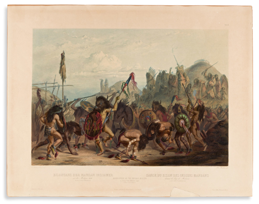

229
(native americans.) karl bodmer.
Bison-Dance of the Mandan Indians in Front of Their Medicine Lodge.

Paris, Coblenz and London, [1841]
Hand-colored aquatint and engraved plate from Prince Maximilian zu Wied-Neuwied’s Travels in the Interior of North America. 16¾x21½ inches sheet size; Bodmer blind stamp at central imprint; fine hand-color with crackled gum arabic; several cracks and creases reinforced on verso, small area of lower margin with paper loss casually reinstated.
Estimate
$500 – $750


230
(native americans.) karl bodmer.
Funeral Scaffold of a Sioux Chief Near Fort Pierre. Tableau 11.

Paris, Coblenz and London, [1841]
Aquatint and engraved plate from Prince Maximilian zu Wied-Neuwied’s Travels in the Interior of North America. Printed on China paper and mounted to a larger folio sheet, 17x23¾ inches overall; Bodmer blind stamp at lower center; uncolored; marginal staining.
Estimate
$500 – $750


231
(native americans.) karl bodmer.
Idols of the Mandan Indians. Tableau 25.

[Leipzig: Schmidt and Guenther, 1922]
Aquatint and engraved plate from Prince Maximilian zu Wied-Neuwied’s Travels in the Interior of North America. 24¾x18 inches sheet size; Bodmer blind stamp at lower center; uncolored; a few soft creases and edge nicks but overall nice.
Estimate
$400 – $600


232
(native americans.) karl bodmer.
Niagara Falls. Tableau 39.

Paris, Coblenz and London, [1841]
Aquatint and engraved plate from Prince Maximilian zu Wied-Neuwied’s Travels in the Interior of North America. 17x24¼ inches sheet size; Bodmer blind stamp at lower center; uncolored; a few soft creases but overall nice.
Estimate
$300 – $400


233
(native americans.) karl bodmer.
Winter Village of the Minatarres. Tableau 26.

Paris, Coblenz and London, [1841]
Aquatint and engraved plate from Prince Maximilian zu Wied-Neuwied’s Travels in the Interior of North America.16¼x21¼ inches sheet size; Bodmer blind stamp at lower center; uncolored; light surface soiling but overall nice.
Estimate
$800 – $1,200


234
(native americans.) e. davis.
Group of 6 modern oil paintings after vintage photographs by David F. Barry, and others.

Np, 20th-century
Oil on canvas; oval portraits measuring approximately 12½x10 inches each; overall canvas sizes approximately 15½x12 inches each; minor flaws.
Low Dog - a fierce Oglala Lakota war chief.
Crow King, or Medicine Bag - Hunkpapa Lakota war chief.
Short Bull - Brulé Lakota, practitioner of the Ghost Dance religion.
Sharp Nose - Northern Arapaho chief in U.S. Army uniform. (after Baker & Johnston).
Rain in the Face - Hunkpapa Lakota war chief. (after L.A. Huffman).
Wolf Robe - Southern Cheyenne chief. (after De Lancey Gill).
Estimate
$400 – $600


235
(native americans – niagara falls.) max beeger.
Les Amours Rêves. En Amerique Au Niagara.

Paris, Berlin, London and New York, circa 1850
Lithographed scene of a native man paddling his female companion in a dug-out canoe on the still waters below Niagara Falls. 17x21¾ inches sheet size, wide margins; exceptional original hand-color with touches of gum arabic; mounted on board, moderate foxing and toning; cover illustration to “Impressions of Niagara, the Charles Rand Penney Collection”, 1993.
Estimate
$500 – $750


236
(new york city.) pierre canot, engraver; after thomas howdell.
A South West View of the City of New York, in North America.

London: Bowles, Sayer, Jefferys, Bowles, and Parker, circa 1768
Hand-colored engraved view of New York Harbor with lower Manhattan at right. Laid paper, 14½x21 inches sheet size; fold at center, even age tone.
Attractive 18th-century view of New York City from the rare Scenographia Americana series (“b3” at lower right corner). Deak, Picturing New York, 116.
Estimate
$800 – $1,200


237
(new york city.) charles mottram; after john w. hill.
New York.

New York: F. & G.W. Smith, 1855
Large hand-colored aquatint and engraved panorama of lower Manhattan. 33¾x53½ inches sheet size, wide margins; archivally lined on verso, small edge wear and soft creases, a few scrapes neatly touched up within image; authentic strike with “Proof” and “Printed by McQueen, London” at lower margin.
Estimate
$2,000 – $3,000


238
(new york city.) john bachmann, (after).
Fifth Avenue from 42nd Street, Looking North * Fifth Avenue from 42nd Street, Looking South.

New York: Max Williams, 1904
Together two chromolithographed birds-eye views of Fifth Avenue, Manhattan, designed “from an old photograph by John Bachman 1879.” 16½x21 inches each sheet size; minor age toning.
Estimate
$250 – $300


239
(new york city.) american lithographic company.
Home Office, Metropolitan Life Insurance Co., Covers an Entire Block, Has a Floor Area of Over 25 Acres and Contains 48 Elevators.

[New York, circa 1910]
Large-scale chromolithographed view of the Met Life Tower and Madison Square Park. 38¾x32½ inches sheet size, wide margins; minor stains at lower edge, else excellent.
Estimate
$250 – $300


240
(niagara falls.) j. merigot, after john vanderlyn.
A Distant View of the Falls of Niagara, Including Both Branches with the Island, and Adjacent Shores, Taken from the Vicinity of the Indian Ladder.

London, 1804
Fine large-scale aquatint and engraved view of the falls after Vanderlyn's 1802 oil painting. 23x29¾ inches sheet size, trimmed to platemark; repairs to lower left title margin and upper sky area.
Estimate
$800 – $1,200


241
(niagara falls.) j.m. butler, after j. hamilton and t. taylor.
Niagara Falls (Canada Side).

Philadelphia: William Smith, circa 1845
Large aquatint and engraved view of Horseshoe Falls with a Maid of the Mist-type steamboat below. 22¾x28¼ inches sheet size, left margin trimmed within platemark; several small edge closures, moderate foxing. Scarce print on the market.
Estimate
$600 – $900


242
(niagara falls.) robert hinshelwood, after j.b. wandesforde.
Niagara.

[New York, 1855]
Large hand-colored steel engraving of a pedestrian gangway leading to Terrapin Point lighthouse at the precipice of the falls. Printed on India paper, 21x27½ inches, mounted to a larger sheet of publisher’s stock, 26½x35¾ inches; proof before imprint and “From a Drawing Made on the Spot, November 1853” subtitle; mount with foxing and stain at upper left, image fine.
Estimate
$400 – $600


243
(niagara falls.) william james bennett, artist and engraver.
Niagara Falls…View of the British Fall Taken from Goat Island.

New York, circa 1830
Hand-colored aquatint. 17½x23¼ inches sheet size; archivally lined on verso stabilizing moderate restorations, lower margin trimmed excising part of the printed caption and publisher’s imprint.
Estimate
$600 – $900


244
(niagara falls.) hippolyte sebron, after.
Les Chutes Du Niagara - La Fer a Cheval / Niagara Falls - The Horse Shoe.

Paris: Boussod Valadon & Cie; and New York: Max Jacoby, [1852]
Large hand-colored aquatint and engraved panorama. 28x42 inches sheet size, wide margins; laid on board, dampstaining and tears to the margins.
Estimate
$400 – $600


245
(peoria, il.) john m. roberts, after.
Peoria Aug 29th, 1831.

Np, mid-19th century
Large format albumen photograph of a sketch by Roberts, considered to be the earliest depicted view of Peoria. 9¼x13½ inches image size, mounted to a larger sheet of period card stock, 14x18 inches; photo with mild vertical slat toning, mount with some tears and chips.
Estimate
$100 – $150


246
(perry – arrival in japan.) [william heine].
Group of 4 full-size photographic facsimiles of Heine’s 1855 large-format lithographs.

Np, 20th century
24x33 inches sight; each mounted, matted, and suitable for decorative framing.
First Landing of Americans in Japan, Under Commodore M.C. Perry at Gore-Hama July 14th 1853.
Landing of Commodore Perry, Officers & Men of the Squadron to Meet the Imperial Commissioners at Yoku-Hama, Japan, March 8th 1854.
Landing of Commodore Perry, Officers & Men of the Squadron, to Meet the Imperial Commissioners at Simoda, Japan, June 8, 1854.
Exercise of Troops in Temple Grounds Simoda Japan, in Presence of the Imperial Commissioners June 8th 1854.
Estimate
$200 – $250

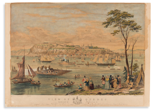

247
(quebec.) captain benjamin beaufoy, after.
View of Quebec.

London: Day & Haghe, circa 1845
Hand-colored lithograph of Old Quebec looking across the St. Lawrence River bustling with ship commerce and pleasure boating. 16x22¼ inches sheet size, narrow top margin; touches of gum arabic; faint mat line, scattered spots of foxing.
Estimate
$500 – $750


248
(remembrance.) d.w. kellogg & co., lithographer.
To the Memory of [Emily, she died, March 9th, 1838. Born March 10th, 1835].

Hartford, CT, circa 1830s
Hand-colored lithographed mourning picture with the memorial of a three-year-old girl and a short Biblical passage inscribed in ink. 15½x12¾ inches sheet size, ample margins; original hand-color with touches of gum arabic; age tone and scattered stains.
Estimate
$100 – $150

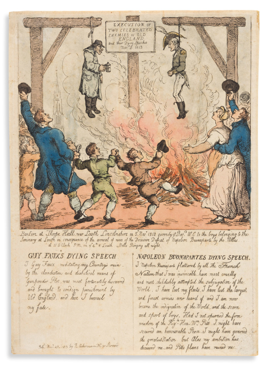

249
(satire.) thomas rowlandson.
Execution of Two Celebrated Enemies of Old England and Their Dying Speeches Nov.r 5, 1813.

London: R. Ackermann, 1813
Hand-colored etching depicting effigies of Guy Fawkes and Napoleon Bonaparte each hanging from a gallows beam above a raging fire while good Britons celebrate the symbolic defeat over the machinations of each villain; the two rogues’ “dying speeches” are laid out below. 13½x9½ inches sheet size, ample margins; soft creases and pale spots of foxing. BM Satires 12103.
Estimate
$400 – $600


250
(satire – napoleon in exile.)
Two hand-colored etched plates.

[Paris, circa 1815]
Les Habitants de St. Helene Prennent la Fuite a la Vue de Leur Nouveau Souverain. 8¾x11¼ inches sheet size; original hand-color; light creasing and soiling.
C'est a Qui n'en Veut Pas Meme Jusques aux Rats. 7½x11¼ inches sheet size; original hand-color; minor soiling.
BM Satires 12711.
Estimate
$200 – $250


251
(shipwrecks – heroism.) john c. mcrae.
My Child! My Child! [and] They’re Saved! They’re Saved!

New York, circa 1855
Together two large engraved acts depicting a woman desperately keeping her baby above the waves and the two of them snatched to safety by a daring rescue. 24x29¾ inches each sheet size, wide margins; light surface age and foxing, few short edge tears.
Scarce histrionic prints; similar in subject and title to a pair of contemporary Currier & Ives lithographs.
Estimate
$300 – $400


252
(vexillology.) hinman & dutton.
The Flags of the Principal Nations of the World.

Philadelphia, 1837
Hand-colored engraved chart of national and city state flags (including the Republic of Texas and several merchant emblems). 17¾x21¾ inches sheet size; original folds, reinstatement of small portions of border design at right.
Estimate
$350 – $450


253
(vues d’optique.)
Group of 12 hand-colored engraved vues.

Paris and London, late eighteenth century
Folio sheets, 17x22 inches or smaller; various imperfections.
General View of the City of Madrid.
Vue des Boulevard prise du premier Caffee pres le Reservoir de la Ville.
Vue du Chateau de St. Ildephonse, prise en fasce des Appartements du Roy d’Espagne.
The Church of St. Mary ye Great at Rome. (Bowles after Piranesi).
Vue de la Mer a Soleil couchant.
Vaisseaux en pleine Mer.
Forum Argentarium Roterodami.
Vue du Grand Caire, (Egypte).
A View of the Seat of Lodovisi with part of Rome.
Vue perspective de la Ville et du Pont de Rouen.
Vue et Perspective de la Samaritaine de Paris.
Vue d’un Temple de Corinthe.
Estimate
$250 – $300


254
(yellowstone.) kurz & allison.
Mammoth Hot Springs. Yellow-Stone Nat’l Park.

Chicago, circa 1890
Large tinted lithograph of four men and a lady boldly exploring the terraced hot springs. 22x28 inches sheet size, wide margins; overall condition is excellent with only a short soft crease at the lower right corner and minor edge wear.
Attractive western subject by Kurz & Allison, more popularly known for their patriotic images of historical American battle scenes. Very scarce, with only two institutional examples located and none at auction.
Estimate
$1,000 – $1,500


255
Angas, george french.
4 hand-colored lithographed plates

London, 1849
from The Kafirs Illustrated. Folio sheets; various toning, staining and mat burn to the margins, images nice.
Estimate
$400 – $500


256
Audubon, john james and john woodhouse.
Black-Tailed Deer. Plate LXXVIII. [and] Northern Meadow-Mouse. Plate CXXIV.

Philadelphia: Bowen, 1845; 1848
Together two hand-colored lithographed plates from Audubon’s Viviparous Quadrupeds of North America. Imperial folio sheets, approximately 20½x26½ inches each sheet size; mat line and other slight toning, a few short closed tears; each with “Merwin’s Art Shop, New Haven” ink stamp to verso.
Estimate
$300 – $500

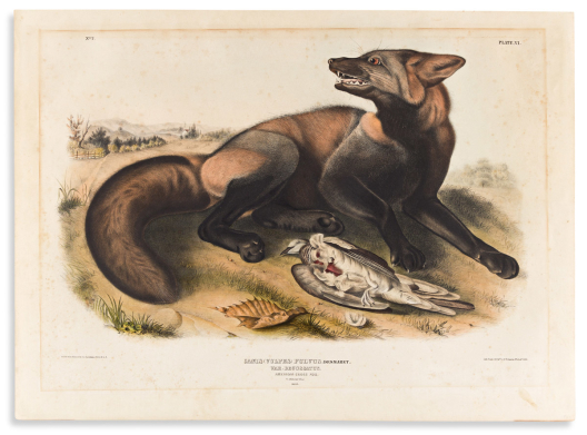

257
Audubon, john james.
American Cross Fox. Plate VI.

Philadelphia: Bowen, 1843
Hand-colored lithographed plate from Audubon’s Viviparous Quadrupeds of North America. Imperial folio, 20¼x27½ inches sheet size; touches of gum arabic; acidic mat line, foxing.
Estimate
$250 – $350


258
Audubon, john james.
American Bison or Buffalo. Plate LVII.

Philadelphia: Bowen, 1845
Hand-colored lithographed plate from Audubon’s Viviparous Quadrupeds of North America. Imperial folio, 20½x26¾ inches sheet size; small repair to upper left corner, two minor paper abrasions at right margin; “Merwin’s Art Shop, New Haven” ink stamp to verso.
Estimate
$5,000 – $7,500


259
Audubon, john james.
Group of three hand-colored tinted lithographed plates,

New York, circa 1856-1871
from a later octavo edition of Birds of America. 10½x6½ inches each sheet size; light mat toning, small chip to one margin. Group comprising: Pl. 368 Great White Heron, Pl. 422 American White Pelican, Pl. 423 Brown Pelican.
Estimate
$500 – $750


260
Audubon, john james.
Group of four hand-colored tinted lithographed plates,

New York, circa 1856-1871
from a later octavo edition of Birds of America. 10½x6½ inches each sheet size; light mat toning, one with a bit of dampstain. Group comprising: Pl. 12 Golden Eagle, Pl. 28 Snowy Owl, Pl. 39 Great Horned Owl, Pl. 376 Canada Goose.
Estimate
$600 – $900


261
Audubon, john james.
Red-Throated Diver. Plate CCII.

London: Robert Havell, 1834
Hand-colored aquatint and engraved plate from Audubon’s Birds of America, on wove paper watermarked: “J Whatman/1836”. 25½x38 inches sheet size, wide margins with upper binding edge; faint mat tone, two short closed tears at upper corners.
Estimate
$6,000 – $9,000


262
Audubon, john james.
Whip-Poor-Will. Plate LXXXII.

London: Robert Havell, [1833]
Hand-colored aquatint and engraved plate from Audubon’s Birds of America, on wove paper watermarked: “J Whatman/1833”. 39¼x26 inches sheet size, wide margins with three sides of deckle edge; faint mat tone, horizontal crease at upper edge; “New York Society Library” ink stamp to verso (Sotheby’s June 7, 1980).
Estimate
$5,000 – $7,500


263
Audubon, john james.
Willow Grous or Large Ptarmigan. Plate CXCI.

London: Robert Havell, 1834
Hand-colored aquatint and engraved plate from Audubon’s Birds of America on wove paper watermarked: “J Whatman/1834”. 25½x38 inches sheet size, binding edge at top; touches of gum arabic; minor chip at lower left corner and two nearby marginal printer’s creases, but overall a fine example with superior original hand-color.
Estimate
$6,000 – $9,000


264
Bellairs, lieutenant walford thomas, after.
View of the Town of St. Thomas, in the West Indies Taken from the Residence of P. Van Vlierden Esqr. [and] View of the Town of St. Thomas, in the West Indies Taken from the Coal Depot of Messrs. Bahnson & Co.

London: Hullmandel & Walton, [1843]
Together two fine hand-colored lithographed views of Charlotte Amalie on the island of St. Thomas, U.S. Virgin Islands. 14¾x21 inches each sheet size, ample margins; touches of gum arabic; laid on heavy card, scattered stains and small marginal tears. Deak 525.
Estimate
$1,200 – $1,800


265
Besler, basilius.
Lilium Cruentum Flore Pleno.

[Eichstatt, 1613]
Hand-colored engraved plate of the double-flowered tiger lily from Hortus Eystettensis on unwatermarked laid paper. 20¾x17 inches sheet size, Latin text on verso; faint mat line, small repair at left margin, colors want refreshing.
Estimate
$350 – $450


266
Bingham, george caleb, after.
The County Election.

New York, 1854
Large hand-colored engraving by John Sartain after Bingham. 24½x32 inches sheet size, ample margins; mounted to board, light age-toning to the margins, a few minor scratches within image.
Estimate
$300 – $400


267
Bodmer, karl.
Cutoff-River. Branch of the Wabash. Vignette VIII.

Paris, Coblenz and London, [1841]
Aquatint and engraved plate from Prince Maximilian zu Wied-Neuwied’s Travels in the Interior of North America.16½x22¾ inches sheet size; Bodmer blind stamp at lower center; uncolored; light foxing.
Estimate
$150 – $200

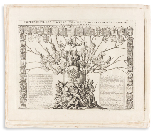

268
Chatelain, henri.
Group of 19 double-page or folding engraved genealogical charts and tables from Atlas Historique.

Amsterdam, circa 1720
Folio sheets; condition generally fine.
Estimate
$150 – $200


269
Crosby, charles h. & co.
[Yosemite Valley, California.]

Boston, circa 1873
Chromolithograph view of Yosemite prominently featuring Bridalveil Fall, El Capitan and Halfdome in the distance. 14x20 inches sheet size, printer’s registration left partly untrimmed at lower edge; archivally mounted to acid-free board, small chip at upper left corner, some discoloration; attractive Eastlake-style wood and gilt period frame.
Estimate
$300 – $400
Lots 270 – 315


270
Currier, nathaniel.
Broadway New York. South from the Park.

New York, circa 1850
Small folio hand-colored lithograph of a bustling mid-nineteenth century lower Broadway. 9¼x13½ inches sheet size; mild age tone but generally very nice.
A fine scene in lower Manhattan featuring Barnum’s American Museum, The Astor House Hotel, Leary & Co. Hatters, St. Paul’s Chapel, and the spire of Trinity Church in the distance.
Estimate
$400 – $600


271
Currier, nathaniel.
City of New York, from Jersey City.

New York, 1849
Small folio hand-colored lithograph of various vessels on the East River with lower Manhattan beyond. 10x14 inches sheet size; generally nice but possibly cleaned.
Described in a 1964 Goodspeed’s Book Shop catalog: “Scarce. You see Little Old New York in a little old lithograph published by N. Currier in 1849, when he was at 152 Nassau Street in that city. The view is from the Jersey side and the Jersey City Ferry is seen in the right foreground, which in this case is water. Manhattan landmarks identified in the caption are: St. Paul’s, the North Dutch, and St. George’s churches, the Post Office, Trinity Church, the Battery, Castle Garden, and Governor’s Island.”
Estimate
$500 – $750


272
Currier, nathaniel.
The Battery, New York. By Moonlight.

New York, 1850
Small folio hand-colored lithograph depicting a scene of moonlight revelry at Manhattan’s lower end with a distant Governors Island across the harbor. 9x12¾ inches sheet size; touches of gum arabic; mild age tone but generally nice.
Estimate
$400 – $600


273
Currier, nathaniel.
The Steamship Washington, Capt. Fitch, Rescuing the Passengers of the Ship Winchester of Boston, Tuesday May 2nd, 1854… From a Sketch by Mr. Vincent, Passenger on Board the Washington.

New York, 1854
Small folio hand-colored lithograph of a historical mid-Atlantic rescue at sea. 10x14 inches sheet size; small repair at lower center margin otherwise nice.
Estimate
$250 – $300


274
Currier, nathaniel.
Outward Bound / Homeward Bound.

New York, circa 1850
Together two small folio hand-colored lithographs of American clipper ships. 10x13¾ inches each sheet size; touches of gum arabic; repaired tear at upper right corner of Outward, minor foxing, soft creases and small edge chips.
Published by Currier prior to his collaboration with James Merritt Ives. Outward depicts a three-masted schooner departing New York Harbor with Castle Williams standing on Governors Island at lower left; Homeward is the identical image to “The Gem of the Pacific”, published by Currier in 1849, with a re-worked title.
Estimate
$500 – $750


275
Currier, nathaniel; after charles severin.
Peytona and Fashion. In Their Great Match for $20,000. Over the Union Course L.I. May 13th, 1845, Won by Peytona.

New York, circa 1845
Large folio hand-colored lithograph of a massive crowd cheering the thoroughbred mares around the track during their epic contest. 20¾x30 inches sheet size; touches of gum arabic; slight age toning but overall excellent with bright original colors.
Not found in auction database records since a 1959 Parke Bernet catalog where it realized $1,900 and was described as “The rarest and finest of the Currier racing prints”.
Estimate
$1,500 – $2,500


276
Currier, nathaniel; after louis maurer.
Tacony and Mac. Hunting Park Course Phila. June 2nd, 1853.

New York, 1853
Large folio hand-colored lithograph of the two jockeyed stallions in a timed heat. 20½x29 inches sheet size; touches of gum arabic; a few minor fox spots and faint slat discoloration but overall very nice.
Estimate
$500 – $750


277
Currier, nathaniel; after john trumbull.
Surrender of Lord Cornwallis at Yorktown Va. Oct. 19th, 1781.

New York, 1852
Large folio hand-colored lithograph symbolizing the end of the American Revolution. 18½x26 inches sheet size; laid on stiff modern canvas stabilizing numerous restorations, but presents well enough.
Estimate
$250 – $300


278
Currier, nathaniel; after j. f.[sic] butterworth [sic].
Clipper Ship “Great Republic”.

New York, 1853
Large folio hand-colored multi-stone lithograph after a painting by James E. Buttersworth, celebrating the ship’s launch in 1853. 20¼x26½ inches sheet size; fine color with touches of gum arabic; registration pinholes; overall excellent.
Estimate
$700 – $1,000


279
Currier, nathaniel; after fanny palmer.
Woodcock Shooting.

New York, 1852
Medium folio hand-colored lithograph of two gentleman hunters with their pointers on the prowl. 15¾x22 inches sheet size; touches of gum arabic; overall toned, laid on heavy card stabilizing several tears and other small restorations.
Estimate
$250 – $300


280
Currier, nathaniel; after louis maurer.
Camping Out. “Some of the Right Sort.”

New York, 1856
Large folio hand-colored lithograph of encamped men drinking, smoking, and proudly regaling each other with the day’s bounty from the woods and stream. 22¼x30¼ inches sheet size; nice original hand color with touches of gum arabic; even age toning, a few small margin closures.
Estimate
$1,000 – $1,500


281
Currier, nathaniel.
Winter Evening.

New York, 1854
Medium folio hand-colored two-stone lithograph of youngsters skating on a frozen country stream with a group of others gathered round the bonfire. 11¾x16 inches sheet size; touches of gum arabic; registration pinholes, overall nice condition; exhibited, and with label: “Currier & Ives: Best Fifty Revisited”, Milwaukee Art Museum, 1990; New Best 50 Small Folio No. 13.
Estimate
$800 – $1,200


282
Currier, nathaniel; after fanny palmer.
American Farm Scenes. No. 4.

New York, 1853
Large folio hand-colored lithograph featuring a horse-drawn sleigh pulling a farmer, his son, and four large milk cans along a snowy road; youth are seen in the background, some at leisure, others at work with chores. 19¼x25¾ inches sheet size; fine colors with touches of gum arabic; minor toning at sheet edges and a few scant spots of foxing but overall a lovely example; exhibited, and with label: “Currier & Ives: Best Fifty Revisited”, Milwaukee Art Museum, 1990; New Best 50 Large Folio No. 8.
Estimate
$3,000 – $5,000


283
Currier, nathaniel; after fanny palmer.
American Winter Scenes. Evening.

New York, 1854
Large folio hand-colored multi-stone lithograph of guests arriving by horse-drawn sleighs to a social ball at the grand country hotel. 21½x27¾ inches sheet size, wide margins; touches of gum arabic; registration pinholes; very faint mat line and vertical slat discolorations but overall quite fine; exhibited, and with label: “Currier & Ives: Best Fifty Revisited”, Milwaukee Art Museum, 1990. New Best 50, Large Folio, No. 19.
Estimate
$3,000 – $5,000


284
Currier & ives; after charles parsons and lyman atwater.
American Steamboats on the Hudson. Passing the Highlands.

New York, 1874
Large folio multi-stone-tinted lithograph of two enormous paddle-steamers (Drew and St. John) passing by each other in the Hudson Highlands. 22½x34½ inches sheet size; registration pinholes; lightly age toned but generally a fine example with no additional hand-coloring.
Estimate
$1,000 – $1,500


285
Currier & ives; after charles parsons.
Steamer Penobscot. One of the Fleet Forming the Line Between Boston, Bangor & Mt. Desert.

New York, 1883
Large folio chromolithograph of a fine-looking New England passenger ship. 27¾x39½ inches sheet size; backed on modern canvas, light marginal stains, creases at upper left.
Estimate
$700 – $1,000


286
Currier & ives; after charles parsons.
The Grand New Steamboat Pilgrim, the Largest in the World.

New York, 1883
Large folio chromolithographed portrait of the beautiful 1200-passenger “Iron Monarch of Long Island Sound.” 26½x37½ inches sheet size; backed on modern canvas, a few short repairs within image.
Estimate
$600 – $900


287
Currier & ives; after charles parsons.
The Grandest Palace Drawing Room Steamers in the World, Drew and St. John, of the People’s Evening Line Between New York & Albany, Passing on the Hudson.

New York 1878
Large folio chromolithographed advertisement-piece for the two luxury passenger steamers. 27x36¾ inches sheet size; backed on modern canvas stabilizing several large repaired tears within image, lower margin replaced with partial reinstatement of some lettering at lower left.
Estimate
$300 – $400


288
Currier & ives; after charles parsons.
Yacht “Puritan” of Boston.

New York, 1885
Large folio chromolithograph of a champion-caliber sailboat with two columns of boat specs laid out at either side of the title. 19x24½ inches sheet size; small tape desiccation spots at upper margin, short closed tear at right edge.
Estimate
$500 – $750


289
Currier & ives; and charles parsons; after j. smith & son.
Clipper Ship “Adelaide”. Off Sandy Hook, “Hove To For a Pilot”.

New York, 1856
Large folio hand-colored lithograph of the large clipper turning sails and slowing her progress to enter New York Bay. 19x26¾ inches sheet size; fine color with touches of gum arabic; large stain at upper left, other small defects.
Estimate
$250 – $300


290
Currier & ives; after j.e. butterworth [sic].
Cutter Yacht “Maria” In Her Trial of Speed with the Clipper Yacht America ni [sic] New York Bay 1851.

New York, [1852]
Large folio hand-colored multi-stone lithograph after a painting by James E. Buttersworth depicting the two sleek yachts racing in a heat. 21¾x27¾ inches sheet size; fine color with touches of gum arabic; registration pinholes; overall excellent.
Estimate
$700 – $1,000


291
Currier & ives.
The American Champion Sloop Yacht Mayflower…Winner of the America’s Cup… Proving Her Superiority at All Points of Sailing.

New York, 1886
Small folio hand-colored lithograph of a sharp-looking vessel. 13x16 inches sheet size; small edge closures. Uncommon print.
Estimate
$200 – $250


292
Currier & ives.
The Brig Vision, Capt. Donovan, on Her Voyage from New York to London, 1864.

New York, circa 1864
Small folio hand-colored lithograph of a brave 15-foot sailboat which by contemporary newspaper accounts made an unsuccessful attempt at a trans-Atlantic crossing. 13½x18 inches sheet size; minor age toning.
Estimate
$200 – $250


293
Currier & ives.
A Midnight Race on the Mississippi.

New York, 1860
Large folio hand-colored two-stone lithograph of a moonlit race between the steamboats “Natchez” and “Eclipse”. 22¾x31¾ inches sheet size, wide margins; restored and laid on stiff modern canvas, needs color. New Best 50, Large Folio, No. 2.
Estimate
$1,000 – $1,500


294
Currier & ives.
“Wooding Up” on the Mississippi.

New York, 1863
Large folio hand-colored two-stone lithograph of the steamboat “Princess” docked at a supply yard loading fuel wood. 23x31¾ inches sheet size, wide margins; mat stain, edge repairs extending slightly into image. New Best 50, Large Folio, No. 23.
Estimate
$2,000 – $2,500


295
Currier & ives; after a.f. tait.
Life of a Hunter. “A Tight Fix.”

New York, 1861
Large folio hand-colored lithograph of an American frontiersman and a large black bear engaged in a fierce clash in the snowy wilderness, each wounded but still fearless. 22¼x29½ inches sheet size; touches of gum arabic; cleaned, small marginal restorations, imprint line below image partially reinstated. New Best 50, Large Folio, No. 16.
Estimate
$15,000 – $20,000


296
Currier & ives; after a.f. tait.
Life of a Hunter. “Catching a Tartar.”

New York, 1861
Large folio hand-colored multi-stone lithograph of a stunned sportsman suddenly stormed by the points of an angry stag he’s freshly shot; a dramatic embodiment of the old idiom from the title. 21¾x28½ inches sheet size; excellent original color with touches of crackled gum arabic; registration pinholes; a few minor marginal repairs, small area at upper left image archivally strengthened on verso.
Estimate
$3,000 – $5,000


297
Currier & ives.
Sunnyside - On The Hudson.

New York, circa 1870
Small folio hand-colored lithograph of the estate of American author Washington Irving on the Hudson River, Tarrytown, NY. 11x15 inches sheet size; touches of gum arabic; a few soft creases, small closure at lower center.
Estimate
$150 – $200


298
Currier & ives.
The Great East River Bridge. To Connect the Cities of New York & Brooklyn.

New York, 1872
Small folio hand-colored lithograph of the Brooklyn Bridge spanning the ship-filled East River. 10½x13½ inches sheet size; touches of gum arabic; minor foxing, small abrasion at upper center; New Best 50 Small Folio No. 31.
A theoretical view - at the time of this publication construction was only two years in and the towers, let alone the span, were nowhere near completion. A short descriptive puff in the lower margin outlines the bridge’s specifications and presumptive cost.
Estimate
$400 – $600


299
Currier & ives.
View on Hudson River. [From Ruggles House, Newburgh].

New York, circa 1865
Small folio hand-colored lithograph of sailboats and a paddle wheeler passing by a stately waterfront mansion in the Hudson Highlands. 9½x13 inches sheet size; touches of gum arabic; small competent repairs, margins trimmed excising lower sub-title.
Estimate
$150 – $200


300
Currier & ives.
The Entrance to the Highlands. Hudson River - Looking South.

New York, 1864
Large folio hand-colored lithograph of a mid-river view showing sailboats and a paddle-steamer cutting up the Hudson, walled on either side by the sylvan Highland cliffs. 18¼x24¼ inches sheet size; fine colors with touches of gum arabic; verso slightly discolored from previous framing, recto quite fine.
Estimate
$1,000 – $1,500


301
Currier & ives; after fanny palmer.
View on the Hudson.

New York, circa 1860
Large-folio hand-colored lithograph of paddle-steamers and sailboats in the Hudson Highlands. 17¼x22¼ inches sheet size; touches of gum arabic; minor toning, small repair at upper center slightly into image.
Estimate
$800 – $1,200


302
Currier & ives; after fanny palmer.
The Hudson River Steamboat “St. John”.

New York, 1864
Large folio hand-colored two-stone lithograph portrait of the impressive side-wheeler steaming up the Hudson decked with passengers. 22½x31½ inches sheet size; touches of gum arabic; registration pinholes; light foxing.
Estimate
$1,200 – $1,800


303
Currier & ives.
Fast Trotters on Harlem Lane N.Y.

New York, 1870
Large folio hand-colored multi-stone lithograph of a lively throng of harness-racers on the Harlem River Speedway, including Cornelius Vanderbilt and his team. 22x31½ inches sheet size; fine original color with touches of gum arabic; registration pinholes; small old repair at upper sheet edge, faint slat discolorations from previous framing.
Estimate
$1,200 – $1,800


304
Currier & ives.
The Champion Trotting Stallion Smuggler…Winning the Great Stallion Race for the Championship of the United States. In the Presence of (Estimated) Forty Thousand Spectators, at Mystic Park Medford, Mass. Sept. 15th, 1874.

New York, 1875
Large folio hand-colored two-stone lithograph of the champion harness-racing stallion trotting his way to a signature victory. 21¾x29½ inches sheet size; touches of gum arabic; registration pinholes; a few soft creases.
Estimate
$500 – $750


305
Currier & ives.
Maiden’s Rock. Mississippi River.

New York, circa 1865
Small folio hand-colored lithograph of two steamboats crossing paths while rounding Maiden Rock Bluff, Wisconsin, on the upper Mississippi River. 11x14 inches sheet size; touches of gum arabic; small edge tears and minor wear.
Estimate
$500 – $750


306
Currier & ives.
Moonlight. The Castle.

New York, circa 1860
Small folio hand-colored lithograph of a couple standing at lake’s edge with a moonlit manor in the distance. 12x13¾ inches sheet size; touches of gum arabic; marginal toning and light water stain; a print not commonly seen.
Estimate
$250 – $300


307
Currier & ives.
American Choice Fruits.

New York, 1869
Large folio hand-colored lithograph of an abundant fruit bowl, a bird’s nest, and a glass water pitcher. 18½x24¾ inches sheet size; touches of gum arabic; evenly age toned.
Estimate
$300 – $400

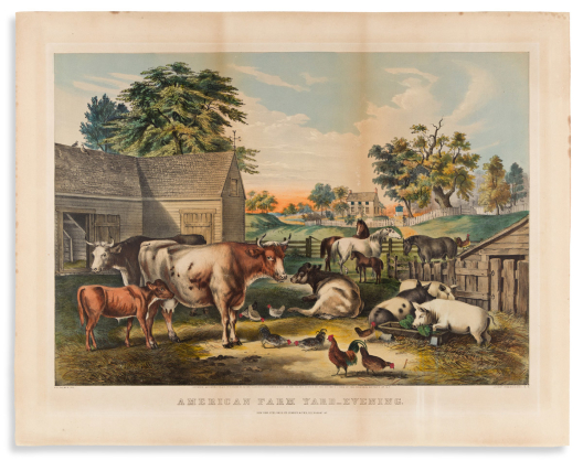

308
Currier & ives; after fanny palmer.
American Farm Yard__Evening.

New York, 1857
Large folio hand-colored lithograph of various barnyard kine, chickens, hogs, and horses at sunset. 21¾x27¾ inches sheet size; attractive colors touched with gum arabic; registration pin-holes at upper image corners, general age toning, vertical slat burn, a few minor surface abrasions.
Estimate
$700 – $1,000


309
Currier & ives; after eastman johnson.
Husking.

New York, 1861
Large folio hand-colored lithographed genre picture depicting a farming family of various age ranges gathered in a barn to carry out the autumn chore of husking bushels of field corn. 23x28¾ inches sheet size; touches of gum arabic; small repair at lower right corner, else an excellent example with rich original colors; exhibited, and with label: “Currier & Ives: Best Fifty Revisited”, Milwaukee Art Museum, 1990. New Best 50, Large Folio, No. 3 (original No. 1).
Estimate
$2,000 – $3,000


310
Currier & ives.
American Homestead Winter.

New York, 1868
Small folio hand-colored lithograph of an idyllic snow-covered farmer’s home and barnyard. 9½x13½ inches sheet size; touches of gum arabic; light sheet discoloration; New Best 50 No. 5.
Estimate
$400 – $600


311
Currier & ives.
Early Winter.

New York, 1869
Medium folio hand-colored lithograph of skaters and fishers on a frozen country pond. 12x18 inches sheet size; minor toning at lower margin but overall quite nice; exhibited, and with label: “Currier & Ives: Best Fifty Revisited”, Milwaukee Art Museum, 1990; New Best 50 Small Folio No. 23.
Estimate
$1,200 – $1,800


312
Currier & ives; after george durrie.
Home to Thanksgiving.

New York, 1867
Large folio hand-colored lithograph of grandparents heartily greeting their visiting family at the farmhouse door. 16¾x26 inches sheet size; touches of gum arabic; lower margin trimmed close to the imprint, but overall a nice example; New Best 50 Large Folio No. 10.
Estimate
$2,500 – $3,500


313
Currier & ives; after george durrie.
The Farmers Home - Winter.

New York, 1863
Large folio hand-colored lithograph of a farmer toting a sheaf of corn stalks to the barnyard on a wintry morning. 19x25¼ inches sheet size; fine colors with touches of gum arabic; faint mat line and other light marginal stains, two small closures at lower edge; exhibited, and with label: “Currier & Ives: Best Fifty Revisited”, Milwaukee Art Museum, 1990; New Best 50 Large Folio No. 37.
Estimate
$2,500 – $3,500


314
Currier & ives; after george durrie.
The Old Homestead in Winter.

New York, 1864
Large folio hand-colored two-stone lithographed scene of a farmer’s grange blanketed in snow. 22x30 inches sheet size; fine colors with touches of gum arabic; registration pinholes; excellent condition with only the slightest age toning.
Estimate
$2,500 – $3,500


315
Currier & ives; after george durrie.
Winter Morning. Feeding the Chickens.

New York, 1863
Large folio hand-colored lithograph of a mother and young daughter tossing scratch to the chickens on a cold snowy morning. 17½x23½ inches sheet size, wide margins; touches of gum arabic; mild toning else quite nice with excellent colors.
Estimate
$1,500 – $2,500


316
Fuller, george; after.
Bound Down the River, Scene on the Lower Mississippi.

New York: M. Knoedler, 1860
Large-format hand-colored lithograph of workers loading bales of commercial cotton onto the Mississippi steamboat “Princess” for transport. 21¼x28 inches sheet size; archivally lined on verso stabilizing a large tear at center and other smaller marginal restorations.
Estimate
$300 – $400


317
Parsons, charles.
Buffalo & Chicago Steam Packet Empire State.

New York: Endicott & Co., circa 1850
Large tinted lithograph with touches of hand-color. 30x45 inches overall; fully restored, backed with modern canvas.
Estimate
$300 – $400


318
Durand, asher b., after.
The Capture of Major Andre.

New York: J.M. Emerson for the American Art Union, 1846
Engraved image of British officer John Andre seized by American patriots after being discovered with secret spy plans hidden in his boot. 23¾x29¼ inches sheet size, extra wide margins; light surface soiling, printer’s creases, ink lettering at lower left corner.
Estimate
$300 – $400


319
Frost, arthur burdett.
Group of 9 chromolithograph plates from Shooting Pictures.

New York, 1895
7 images, 2 in duplicate; 13x20 inches each sheet size, no mounts; dampstain at upper left, scattered edge chips and tears.
Estimate
$500 – $750


320
Kurz & allison.
Group of 4 chromolithographed American battle scenes.

Chicago, late-19th to early-20th centuries
22x27½ inches or smaller, wide margins; overall excellent with bright colors and no damages of note.
Battle of New Orleans - January 8th, 1815. British (Gen. Pakenham) Loss: Gen. Pak. & Over 2000 Killed & Wounded. American (Gen. Jackson) Loss: 7 Killed & 6 Wounded.
Battle of Atlanta - Death of Gen. James B. McPherson - July 22nd, 1864. Army of the Tennessee Engaged.
Battle of Opequan or Winchester, Va. - Sept 19th, 1864. Union: (Gen Sheridan) Loss: 653 Killed, 3,719 Wounded, 618 Missing. Conf. (Gen. Early) 1500 Killed, 2,000 Wounded, 2,500 Pris.
Battle of Princeton - Washington’s Charge January 3rd, 1777. American Loss: Gen. Mercer and About 100 Men. British Loss: Killed & Wounded 200. 300 Prisoners and Cannons Taken.
Estimate
$700 – $1,000


321
Moran, thomas.
[Grand Canyon of Arizona From Hermit Rim Road].

New York: Printed by American Lithographic Co., and published by Atchison, Topeka and Santa Fe Railway System, 1913
Fine chromolithograph after Moran’s oil painting. 24½x34½ inches sheet size, without margins and title; unobtrusive tide-mark at lower edge, a few small abrasions filled-in, else nice.
Estimate
$700 – $1,000


322
P. stampa.
Peace. [and] Plenty.

London, 1799
Together two hand-colored allegorical mezzotints. 14x10 inches each sheet size, small scattered stains and edge chips.
Estimate
$250 – $300


323
Piranesi, giovanni battista.
Colonna Trajana.

Rome, 1758
Etched plate of Trajan’s Column and the Church of the Most Holy Name of Mary from Vedute di Roma. Laid paper with encircled Fleur de Lys watermark, 22¼x16¾ inches sheet size, wide margins; archivally lined on verso, minor edge wear. Hind 51, third state (of 7).
Estimate
$1,200 – $1,800


324
Piranesi, giovanni battista.
Piramide di C. Cestio.

Rome, 1756
Etched plate of the Pyramid of Gaius Cestius from Vedute di Roma. Laid paper, 20½x25½ inches sheet size, wide margins; vertical printer’s creases. Hind 36, first state (of 3).
Estimate
$800 – $1,200


325
Piranesi, giovanni battista.
Group of 6 later-struck etched plates from Vedute di Roma.

Rome: Regia Calcografia, late 19th-century
Heavy wove stock with deep platemarks and circular “Regia Calcografia di Roma” blindstamp at lower right corners. Sheets 20x29 inches or smaller, ample margins; generally nice.
Veduta del Tempio della Sibilla in Tivoli.
Veduta in prospettiva della gran Fontana dell’Acqua Vergine detta di Trevi Architettura di Nicola Salvi.
Veduta dell’Arco di Settimio Severo.
Tempio detto volgarmte di Giano.
Veduta del Pantheon d’Agrippa.
Villa Panfili fuori di Porta S. Pancrazio.
Estimate
$1,000 – $1,500


326
Pope, alexander.
Upland Game Birds and Water Fowl of the United States.

New York: Charles Scribner’s Sons, 1878
Group of 20 chromolithographed plates of ducks, quail, grouse, and snipe (lacking two from the set; two images in duplicate). 14x20 inches each sheet size; loose and removed from mounts (2 still attached but trimmed to plate), minor edge nicks and faint mat lines but images overall nice; with publisher’s gilt cloth portfolio, excised title-page, and descriptive text leaves.
Estimate
$1,200 – $1,800


327
Redouté, pierre-joseph.
Group of 3 hand-finished color-printed stipple engravings,

Paris, 1802-1816
from the "Grand-Papier" edition of Redouté's Liliacées. Approximately 23x17½ inches each sheet size, large paper with binding edges; generally very clean; each with corresponding letterpress text leaf.
Canna Gigantea (Broad-leaved Canna).
Haemanthus Multiflorus (Many-flowered Blood-Umbel).
Gladiolus Tubatus (Long-tubed Baboon-Potato).
Estimate
$500 – $750


328
Rowlandson, thomas.
[Caught in the Act].

[London], 1790
Ink and watercolor drawing of a bedroom scene, interrupted. 8½x11½ inches sight; signed and dated lower left; laid down to acidic board with resultant toning, top mat fixed to margins.
Estimate
$500 – $750

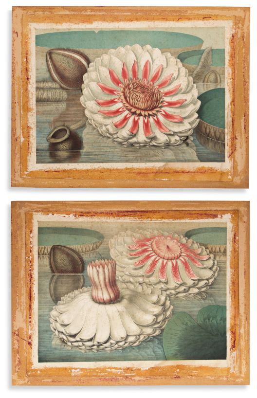


329
Sharp, william.
Victoria Regia; or the Great Water Lily of America.

Boston, 1854
4 large chromolithographed plates showing different life phases of giant flowering water lilies. Approximately 18½x23¾ inches each sheet size; registration pinholes; a considerable restoration project - foxed, mounted to card, desiccated adhesive staining to margins.
Estimate
$1,500 – $2,500


330
Thornton, robert john.
Large Flowering Sensitive Plant * Indian Reed.

London, 1799 and 1804 [but after]
Together two hand-finished color-printed aquatint and stipple-engraved plates from the folio edition of Thornton’s Temple of Flora on heavy wove paper watermarked “HSmith/1810” and “JWhatman/1810” respectively. 23¼x18½ inches each sheet size; light mat stains, tide mark to the former.